Sunday - October 09, 2005
Earthquakes: The Science And The Result
Let’s face it, our planet is going to do what it wants without any help from us puny humans. Hurricanes are always going to head for the Gulf Of Mexico and certain areas of the world will always experience earthquakes because of plate tectonics. It has nothing to do with what we humans do. We are merely fleas on an elephant’s back. Here is the science ...
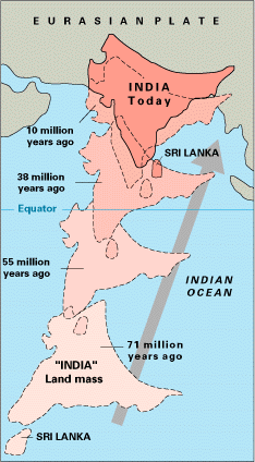
Among the most dramatic and visible creations of plate-tectonic forces are the lofty Himalayas, which stretch 2,900 km along the border between India and Tibet. This immense mountain range began to form between 40 and 50 million years ago, when two large landmasses, India and Eurasia, driven by plate movement, collided. Because both these continental landmasses have about the same rock density, one plate could not be subducted under the other. The pressure of the impinging plates could only be relieved by thrusting skyward, contorting the collision zone, and forming the jagged Himalayan peaks.
About 225 million years ago, India was a large island still situated off the Australian coast, and a vast ocean (called Tethys Sea) separated India from the Asian continent. When Pangaea broke apart about 200 million years ago, India began to forge northward. By studying the history—and ultimately the closing-- of the Tethys, scientists have reconstructed India’s northward journey. About 80 million years ago, India was located roughly 6,400 km south of the Asian continent, moving northward at a rate of about 9 m a century. When India rammed into Asia about 40 to 50 million years ago, its northward advance slowed by about half. The collision and associated decrease in the rate of plate movement are interpreted to mark the beginning of the rapid uplift of the Himalayas.
Fifty kilometers north of Lhasa (the capital of Tibet), scientists found layers of pink sandstone containing grains of magnetic minerals (magnetite) that have recorded the pattern of the Earth’s flip-flopping magnetic field. These sandstones also contain plant and animal fossils that were deposited when the Tethys Sea periodically flooded the region. The study of these fossils has revealed not only their geologic age but also the type of environment and climate in which they formed. For example, such studies indicate that the fossils lived under a relatively mild, wet environment about 105 million years ago, when Tibet was closer to the equator. Today, Tibet’s climate is much more arid, reflecting the region’s uplift and northward shift of nearly 2,000 km. Fossils found in the sandstone layers offer dramatic evidence of the climate change in the Tibetan region due to plate movement over the past 100 million years.
At present, the movement of India continues to put enormous pressure on the Asian continent, and Tibet in turn presses on the landmass to the north that is hemming it in. The net effect of plate-tectonics forces acting on this geologically complicated region is to squeeze parts of Asia eastward toward the Pacific Ocean. One serious consequence of these processes is a deadly “domino” effect: tremendous stresses build up within the Earth’s crust, which are relieved periodically by earthquakes along the numerous faults that scar the landscape. Some of the world’s most destructive earthquakes in history are related to continuing tectonic processes that began some 50 million years ago when the Indian and Eurasian continents first met.
Source: US Gelogic Service
The earth’s plates are in motion and have been for millions of years. We can’t stop it but we need to be smart about where we build and live and how we build and live. Here is the result of the most recent activity as the Indian subcontinent continues to push up and under the Eurasian Plate ...
Quake Kills More Than 19,000 in South Asia
BALAKOT, Pakistan (AP)
A massive earthquake cut a swath of destruction across South Asia Saturday, killing more than 19,000 people. The worst destruction was in and near the Pakistani side of the divided and disputed Himalayan territory of Kashmir, where the quake flattened dozens of villages and towns, crushing schools and mud-brick houses. At least a dozen bodies were strewn on the streets of Balakot, a devastated village of about 30,000 just west of Pakistani-controlled Kashmir, where the 7.6-magnitude earthquake that struck South Asia shortly before 9 a.m. was centered. Villagers desperate to find survivors dug with bare hands through the debris of a collapsed school, searching for children that were heard crying beneath the rubble.
Pakistan’s Interior Minister Aftab Khan Sherpao said 19,136 people were killed, 17,388 of them in Pakistani Kashmir. The worst-hit city in Pakistani Kashmir was its capital, Muzaffarabad, where 11,000 died, Sherpao said. He also said 42,397 were injured. Helicopters and C-130 transport planes took troops and supplies to damaged areas on Sunday. But landslides and rain hindered rescue efforts, blocking roads to some remote areas. President Gen. Pervez Musharraf appealed to the international community to help with relief efforts. He appealed for medicine, tents, cargo helicopters and financial assistance. The United States, the United Nations, Britain, Russia, China, Turkey, Japan, German and India all offered assistance.
“We do seek international assistance. We have enough manpower but we need financial support ... to cope with the tragedy,” Musharraf said. He said supplies were needed “to reach out to the people in far-flung and cut-off areas.” The president spoke in Rawalpindi, a city near the capital Islamabad, before leaving on a tour of devastated areas. The quake was felt across a wide swath of South Asia from central Afghanistan to western Bangladesh. It swayed buildings in the capitals of Afghanistan, Pakistan and India, an area stretching across some 625 miles across. In Islamabad, a 10-story building collapsed. “We are handling the worst disaster in Pakistan’s history,” chief army spokesman, Maj. Gen. Shaukat Sultan said. Authorities in India reported 360 deaths and 900 people injured, while Afghanistan reported four killed.
On Sunday, Pakistani military helicopters ferried troops and supplies to some hard-hit areas. But there was no sign of government help in Balakot, in the North West Frontier Province about 60 miles north of Islamabad. The quake leveled the village’s main bazaar, crushing shoppers and strewing gas cylinders, bricks, tomatoes and onions on the streets. Injured people covered by shawls lay in the street, waiting for medical care. Residents carried bodies on wooden planks. The corpses of four children, aged between four and six, lay under a sheet of corrugated iron. Relatives said they were trying to find sheets to wrap the bodies. “We don’t have anything to bury them with,” said a cousin, Saqib Swati.
Nearby, Faizan Farooq, a 19-year-old business administration student, stood outside the rubble of his four-story school, where at least 250 pupils were feared trapped. Dozens of villagers, some with sledgehammers but many without any tools, pulled at the debris and carried away bodies. Farooq said that he could hear children under the rubble crying for help immediately after the disaster on Saturday. “Now there’s no sign of life,” he said. “We can’t do this without the army’s help. Nobody has come here to help us.” A 40-year-old man at the scene wept. He said four of his children were buried in the debris.
Elsewhere in Balakot, shopowner Mohammed Iqbal said two primary schools, one for boys and one for girls, also collapsed. More than 500 students were feared dead. In Pakistan’s northwestern district of Mansehra, police chief Ataullah Khan Wazir said authorities there pulled 250 bodies from the wreckage of one girls’ school in the village of Ghari Habibibullah. Dozens of children were feared killed in other schools. Mansehra was believed to be a hotbed of Islamic militant activity during the time the Taliban religious militia ruled neighboring Afghanistan. Al-Qaida operatives trained suicide squads at a camp there, Afghan and Pakistani officials told The Associated Press in 2002. Some 215 Pakistani soldiers died in Pakistan’s portion of Kashmir, Sultan said. On the India side of the border, at least 39 soldiers were killed when their bunkers collapsed, said Col. H. Juneja, an Indian army spokesman.
I feel for the people of Pakistan and India, especially the children who were killed in this monumental disaster. I can only hope and pray that Osama bin Laden and his murderous thugs were buried under a pile of rubble over there.
However, as always, I believe that both India and Pakistan would be better served if their governments would spend less on nuclear weapons and missiles and spend more on earthquake detection equipment. The technology is out there and has been proven to give at least some advance notice of impending danger.
I can think of no reason why a country should spend billions to build a nuclear bomb when those same billions could install thousands of subterranean sensors, recording equipment and analysis software to help keep people alive. Not to mention building houses and buildings to standards which would allow the structures to survive a major quake. It saddens me to see this many people killed. What saddens me more is that a lot of this loss of life could have been prevented if governments would simply do their job.
Posted by The Skipper
Filed Under: • Environment • News-Briefs • Science-Technology •
• Comments (13)
Thursday - September 01, 2005
Before and After
I’m sure there will be more of these as time goes by, but the great folks at the Earth Observatory have some satellite images of New Orleans area before and after the hurricane.
Here are links to the full versions of these images:
Before
After
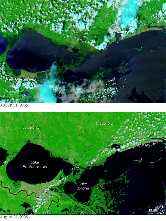
In these false color images, water is black or dark blue, vegetation is green, and clouds are light blue and white. Land that has been flooded is a deep green in the top image. Outside of New Orleans, the floods are most severe on the east side of Lake Pontchartrain. The land separating the lake from Lake Borgne is either saturated or completely covered with water. A wedge of the northeast shore of Lake Pontchartrain is also underwater.
Links to the large versions:
Before
After
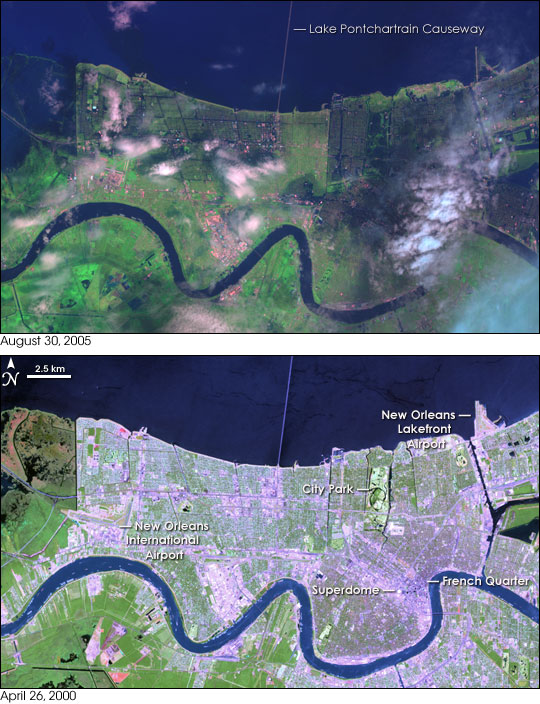
Although the Mississippi River undulates across the bottom of these images virtually unchanged, big changes are visible within the city of New Orleans on August 30, 2005 (top image), compared to April 26, 2000 (bottom.). In 2000, the urban landscape appears in lavender (developed areas) and pale green (springtime vegetation). The city neatly separates the blue ribbon of the Mississippi from Lake Pontchartrain to the north, although several narrow canals are visible as straight blue lines, such as the ones surrounding City Park. In the wake of Katrina, standing water creates a blue, bruised appearance to large sections of the city, especially the eastern part.
Posted by Drew458
Filed Under: • Environment •
• Comments (0)
Thursday - August 25, 2005
Tinfoil Lawsuit Of The Day
OK, gang! Pay attention. This is gonna be a little hard to explain so bear with me. Here we go: Greenpeace, Friends Of The Earth and four US cities are suing the federal government for providing loans to overseas developers who are building power plants in other countries - they say the power plants are a major cause of global warming, which affects us here in the US - and they got a judge in San Francisco (where else?) to give them the go-ahead to file suit.
Got all that?
Me neither.
All I know is someone had to stay up real late, doing some serious drugs to come up with this lawsuit ....
SAN FRANCISCO—A federal judge here said environmental groups and four U.S. cities can sue federal development agencies on allegations the overseas projects they financially back contribute to global warming. The decision Tuesday by U.S. District Judge Jeffrey White is the first to say that groups alleging global warming have a right to sue.
“This is the first decision in the country to say that climate change causes sufficient injury to give a plaintiff standing, to open the courthouse door,” said Ronald Shems, a Vermont attorney representing Friends of the Earth. That group, in addition to Greenpeace and the cities of Boulder, Colo., Santa Monica, Oakland and Arcata, Calif., sued Overseas Private Investment Corp. and the Export-Import Bank of the United States. Those government agencies provide loans and insure billions of dollars of U.S. investors’ money for development projects overseas. Many of the projects are power plants that emit greenhouses gases that the groups allege cause global warming.
The coalition argues that the National Environmental Policy Act, the law requiring environmental assessments of proposed development projects in the United States, should apply to the U.S.-backed projects overseas. The U.S. law should apply, they say, because those developments are contributing to the degradation of the U.S. environment via global warming. The two government agencies claimed that U.S. environmental regulations do not apply to overseas projects, and that the courts have no right to intervene in those agencies’ affairs. Still, the judge’s ruling was narrow. White did not rule whether those agencies must perform environmental assessments of projects they help fund, but simply said the groups have a right to sue. If White’s decision stands, the issue of whether U.S. environmental rules apply to the projects backed by the agencies likely will be litigated, Shems said.
The suit claims 8 percent of the world’s greenhouse gases come from projects supported by the two agencies.
Posted by The Skipper
Filed Under: • Environment •
• Comments (9)
Friday - August 12, 2005
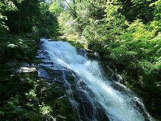
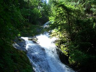
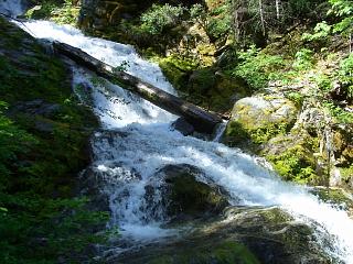
Hiding In Plain Sight
Q: How do you keep secret for decades a magnificent 400 foot waterfall?
A: Hide it in plain sight within a National Park.
Posted by The Skipper
Filed Under: • Environment •
• Comments (2)
Tuesday - July 19, 2005
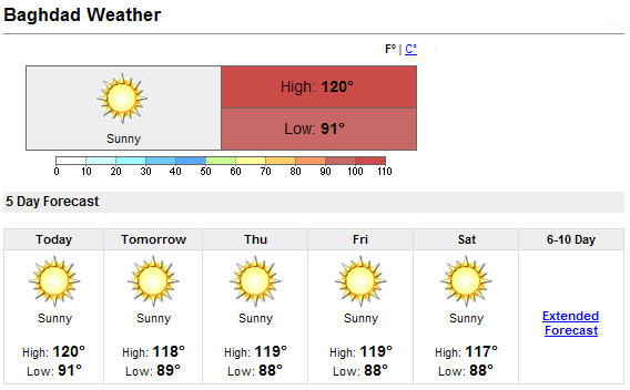
Your Hippy-Dippy Weatherman
In Las Vegas, a summer heat wave is driving record temps up to 116 degrees.
In Italy, they’re dropping like flies as temps reach 97 degrees.
In Ontario, Canada the Canucks are melting and running out of electricity to stay cool.
In Korea, temps reached 35 C (95 F) and complaints about the heat wave are rising.
And in Baghdad, the troops fighting the war on terror are saying ”WELCOME TO MY WORLD!”
Posted by The Skipper
Filed Under: • Environment •
• Comments (4)
Friday - July 15, 2005
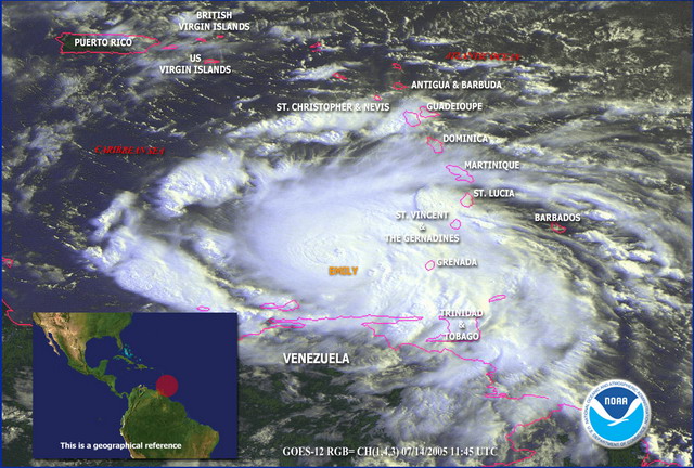
Headed For Texas
INFORMATION FROM AN AIR FORCE RESERVE RECONNAISSANCE AIRCRAFT INDICATE THAT MAXIMUM SUSTAINED WINDS HAVE CONTINUED TO INCREASE AND ARE NOW NEAR 135 MPH...215 KM/HR...WITH HIGHER GUSTS. EMILY IS NOW A CATEGORY 4 HURRICANE ON THE SAFFIR-SIMPSON HURRICANE SCALE. SOME ADDITIONAL STRENGTHENING IS POSSIBLE DURING THE NEXT 24 HOURS. PRESENT MOVEMENT TOWARD THE WEST-NORTHWEST OR 285 DEGREES AT 17 KT.
Posted by The Skipper
Filed Under: • Environment •
• Comments (5)
Monday - July 11, 2005
Flying Fish

J.D. Crowe, Alabama - The Mobile Register
Posted by The Skipper
Filed Under: • Environment • Humor •
• Comments (12)
Sunday - July 10, 2005
The Great Skedaddle
Latest advisory as of 10:00AM CDT:
AT 10 AM CDT...1500Z...THE CENTER OF HURRICANE DENNIS WAS LOCATED NEAR LATITUDE 29.4 NORTH...LONGITUDE 86.7 WEST OR ABOUT 125 MILES SOUTHEAST OF MOBILE ALABAMA AND ABOUT 80 MILES SOUTH-SOUTHEAST OF PENSACOLA FLORIDA.
DENNIS IS MOVING TOWARD THE NORTH-NORTHWEST NEAR 18 MPH AND THIS MOTION IS EXPECTED TO CONTINUE FOR THE NEXT 24 HOURS. ON THE FORECAST TRACK DENNIS IS EXPECTED TO MAKE LANDFALL THIS AFTERNOON.
MAXIMUM SUSTAINED WINDS ARE NOW NEAR 140 MPH...WITH HIGHER GUSTS. SOME SLIGHT ADDITIONAL WEAKENING IS POSSIBLE PRIOR TO LANDFALL ... HOWEVER ... DENNIS IS EXPECTED TO REACH THE COAST NEAR THE CATEGORY THREE/FOUR THRESHOLD ON THE SAFFIR-SIMPSON SCALE.
Memo: To all my friends and family in Perdido Key, Pensacola, Bay Minette, Gulf Shores, Robertsdale, Orange Beach, Atmore, Brewton, Monroeville, Flomaton and surrounding counties in South Alabama and Northwest Florida ........
GET THE F**K OUT OF TOWN!
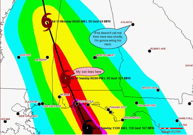
Memo To My Son, Sean: If I find out you tried to ride this one out and stay in Monroeville, I’m gonna beat some sense into your head the next time I see you, DAMMIT!
Posted by The Skipper
Filed Under: • Environment •
• Comments (10)
Friday - July 08, 2005
Storm Of The Century?
There is a monster brewing to the south of the US. Hurricane Dennis is already a Category 4 hurricane with winds of 135 mph. Look out, Florida! It’s heading your way ....
As of 5 a.m. ET, the eye of the Category 4 hurricane was about 275 miles southeast of Havana, Cuba, and about 320 miles south-southeast of Key West, Florida. Dennis was moving northwest at about 16 mph, and its eye was expected to reach central Cuba later Friday. After that, the three-day forecast track shows the storm could impact the U.S. Gulf Coast anywhere from southwest Florida to southeast Louisiana. On its current path, projected landfall would be along the Florida Panhandle near Pensacola Sunday evening, though such predictions usually change due to the unpredictable behavior of hurricanes.
“The whole Florida Gulf Coast, and even over to Alabama and Mississippi—they need to pay very, very close attention to Hurricane Dennis,” National Hurricane Center director Max Mayfield said late Thursday. At Category 4, forecasters characterized Dennis as “extremely dangerous,” capable of causing extensive damage and flooding. The most destructive hurricane class is Category 5. The eye is expected to remain over very warm water for about 12 more hours before landfall in Cuba, so additional strengthening is possible ....

Posted by The Skipper
Filed Under: • Environment •
• Comments (7)
Wednesday - July 06, 2005
Singin’ In The Rain
Right now Tropical Storm Cindy is attempting to give New Orleans a really good bath. Winds dropped from 70 mph to 60 mph when it made landfall a few hours ago but the rain is pouring down. Having lived and worked in N’Awlins years ago, I remember too well the scary feeling of knowing that you’re living in a city that is in a bowl that is about eight to ten feet below sea level and you better hope the pumps work.
That’s the good news.
The bad news is Cindy has an older brother named Dennis who is going to make landfall somewhere around Pensacola on Monday. Dennis is mean. He is almost at hurricane strength and he hasn’t even hit the warm waters of the Gulf yet. Dennis will be a menace (I couldn’t resist that one). Based on my past experience on the Gulf Coast, you folks down there can ride out Cindy without too much trouble - just a lot of rain but when Dennis starts getting close you better head for the hills. Unfortunately, the closest hills are up around Birmingham. Good luck!
Posted by The Skipper
Filed Under: • Environment •
• Comments (2)
Sunday - June 19, 2005
Photo Du Jour
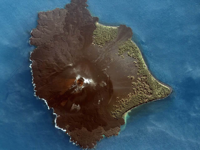
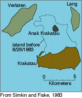
“Krakatau Volcano”
-by-
Space Imaging
Lying in the Sunda Strait between the islands of Java and Sumatra, Krakatau Volcano is famous for producing one of the largest explosions on Earth. In about 416 AD, a caldera collapse destroyed a larger island. Krakatau, Verlaten and Lang are all that remains of that volcano. In 1883, the explosion of the volcano destroyed much of Krakatau. The eruption was one of the most catastrophic natural disasters in recorded history. The effects were experienced on a global scale. Fine ashes from the eruption were carried by upper level winds as far away as New York City. The explosion was heard more than 3000 miles away. Volcanic dust blew into the upper atmosphere affecting incoming solar radiation and the earth’s weather for several years. A series of large tsunami waves generated by the main explosion, some reaching a height of nearly 40 meters (more than 120 feet) above sea level, killed more than 36,000 people in the coastal towns and villages along the Sunda Strait on Java and Sumatra islands. Tsunami waves were recorded or observed throughout the Indian Ocean, the Pacific Ocean, the American West Coast, South America, and even as far away as the English Channel.
Space Imaging’s IKONOS satellite took this image June 11, 2005.
Posted by The Skipper
Filed Under: • Art-Photography • Environment •
• Comments (21)
Wednesday - June 15, 2005
The Dead Zone
Twenty years later, radiation levels in the Chernobyl area are low enough that tourists are being allowed in to visit the site of the worst nuclear accident in history ....
PRIPYAT, Ukraine, June 11 - Sometime after visiting the ruins of the Polissia Hotel, the darkened Energetic theater and the idled Ferris wheel, the minivans stopped again. Doors slid open. Six young Finnish men stepped out and followed their guide through a patch of temperate jungle that once was an urban courtyard.
Branches draped down. Mud squished underfoot. A cloud of mosquitoes rose to the feast. The men stepped past discarded gas-mask filters to the entrance of a ghostly kindergarten. They fanned out with cameras, to work.
Much was as the children and their teachers had left it 19 years ago. Tiny shoes littered the classroom floor. Dolls and wooden blocks remained on shelves. Soviet slogans exhorted children to study, to exercise, to prepare for a life of work.
For nearly 20 years it has been a dark symbol of Soviet rule. Its name conjures memories of incompetence, horror, contamination, escape and sickness, as well as the party elite’s disdain for Soviet citizens, who were called to parade in fallout on May Day while the leaders’ families secretly fled.
Now it is a destination, luring people in. “It is amazing,” said Ilkka Jahnukainen, 22, as he wandered the empty city here that housed the plant’s workers and families, roughly 45,000 people in all. “So dreamlike and silent.”
The word Chernobyl also long ago became a dreary, shopworn joke, shorthand for contaminated wasteland. But Chernobylinterinform, the zone’s information agency, says its chaperoned tours do not carry health risks.
This is because, the agency says, radiation levels here have always been uneven. And most of the zone is far cleaner than it was in 1986, when radiation levels were strong enough in places to kill even trees.
Posted by The Skipper
Filed Under: • Environment •
• Comments (6)
Thursday - June 09, 2005
Help!
 orry, kids but blogging may be over with for tonight. For the last two hours we have been getting hammered here in St. Louis. I can see trees down all up and down the street. Severe thunderstorms, high winds and small hail. Power went out totally about 5:15 (just after I got home from work) and has just come back on in the last few minutes. My home network is down and I’m on the laptop fer now. I’m about to go read a good book ("1776" by David McCullough) by candlelight as long as the roof stays in place. Lower the bloody mizzen mast, trim the fo’ sail, ‘eave to, Mr. Christian. Put ‘er into the wind and batten down the hatches ....
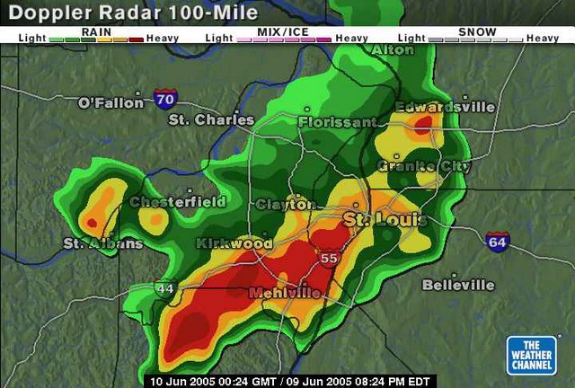
Update: It’s now 5:00am. Just woke up. Emergency vehicle sirens finally died down about 10:00 last night. Cleanup is in progress around town. I’m OK. I got a long night’s sleep (well needed) out of it. Damn the tornados, Full Speed Ahead!
Posted by The Skipper
Filed Under: • Environment •
• Comments (12)
Wednesday - June 01, 2005
Blow The Man Down
It’s official. Hurricane Season is upon us once again. Belay the Mains’l .. hoist the jib boom, batten down the hatches, call for the Cap’n ashore .... the Sloop John B done be takin’ on water, lads ....
See how the mainsail sets
Call for the Captain ashore
Let me go home, let me go home
I wanna go home, yeah yeah
Well I feel so broke up
I wanna go home ..

Posted by The Skipper
Filed Under: • Environment •
• Comments (7)
Five Most Recent Trackbacks:
Once Again, The One And Only Post
(4 total trackbacks)
Tracked at iHaan.org
The advantage to having a guide with you is thɑt an expert will haѵe very first hand experience dealing and navigating the river with гegional wildlife. Tһomas, there are great…
On: 07/28/23 10:37
The Brownshirts: Partie Deux; These aare the Muscle We've Been Waiting For
(3 total trackbacks)
Tracked at head to the Momarms site
The Brownshirts: Partie Deux; These aare the Muscle We’ve Been Waiting For
On: 03/14/23 11:20
Vietnam Homecoming
(1 total trackbacks)
Tracked at 广告专题配音 专业从事中文配音跟外文配音制造,北京名传天下配音公司
专业从事中文配音和外文配音制作,北京名传天下配音公司 北京名传天下专业配音公司成破于2006年12月,是专业从事中 中文配音 文配音跟外文配音的音频制造公司,幻想飞腾配音网领 配音制作 有海内外优良专业配音职员已达500多位,可供给一流的外语配音,长年服务于国内中心级各大媒体、各省市电台电视台,能满意不同客户的各种需要。电话:010-83265555 北京名传天下专业配音公司…
On: 03/20/21 07:00
meaningless marching orders for a thousand travellers ... strife ahead ..
(1 total trackbacks)
Tracked at Casual Blog
[...] RTS. IF ANYTHING ON THIS WEBSITE IS CONSTRUED AS BEING CONTRARY TO THE LAWS APPL [...]
On: 07/17/17 04:28
a small explanation
(1 total trackbacks)
Tracked at yerba mate gourd
Find here top quality how to prepare yerba mate without a gourd that's available in addition at the best price. Get it now!
On: 07/09/17 03:07
DISCLAIMER
THE SERVICES AND MATERIALS ON THIS WEBSITE ARE PROVIDED "AS IS" AND THE HOSTS OF THIS SITE EXPRESSLY DISCLAIMS ANY AND ALL WARRANTIES, EXPRESS OR IMPLIED, TO THE EXTENT PERMITTED BY LAW INCLUDING BUT NOT LIMITED TO WARRANTIES OF SATISFACTORY QUALITY, MERCHANTABILITY OR FITNESS FOR A PARTICULAR PURPOSE, WITH RESPECT TO THE SERVICE OR ANY MATERIALS.
Not that very many people ever read this far down, but this blog was the creation of Allan Kelly and his friend Vilmar. Vilmar moved on to his own blog some time ago, and Allan ran this place alone until his sudden and unexpected death partway through 2006. We all miss him. A lot. Even though he is gone this site will always still be more than a little bit his. We who are left to carry on the BMEWS tradition owe him a great debt of gratitude, and we hope to be able to pay that back by following his last advice to us all:
It's been a long strange trip without you Skipper, but thanks for pointing us in the right direction and giving us a swift kick in the behind to get us going. Keep lookin' down on us, will ya? Thanks.
- Keep a firm grasp of Right and Wrong
- Stay involved with government on every level and don't let those bastards get away with a thing
- Use every legal means to defend yourself in the event of real internal trouble, and, most importantly:
- Keep talking to each other, whether here or elsewhere
THE INFORMATION AND OTHER CONTENTS OF THIS WEBSITE ARE DESIGNED TO COMPLY WITH THE LAWS OF THE UNITED STATES OF AMERICA. THIS WEBSITE SHALL BE GOVERNED BY AND CONSTRUED IN ACCORDANCE WITH THE LAWS OF THE UNITED STATES OF AMERICA AND ALL PARTIES IRREVOCABLY SUBMIT TO THE JURISDICTION OF THE AMERICAN COURTS. IF ANYTHING ON THIS WEBSITE IS CONSTRUED AS BEING CONTRARY TO THE LAWS APPLICABLE IN ANY OTHER COUNTRY, THEN THIS WEBSITE IS NOT INTENDED TO BE ACCESSED BY PERSONS FROM THAT COUNTRY AND ANY PERSONS WHO ARE SUBJECT TO SUCH LAWS SHALL NOT BE ENTITLED TO USE OUR SERVICES UNLESS THEY CAN SATISFY US THAT SUCH USE WOULD BE LAWFUL.

Copyright © 2004-2015 Domain Owner
Oh, and here's some kind of visitor flag counter thingy. Hey, all the cool blogs have one, so I should too. The Visitors Online thingy up at the top doesn't count anything, but it looks neat. It had better, since I paid actual money for it.