Wednesday - March 14, 2007
Green Britannia
Can someone explain to me why the Brits haven’t crept out in the dead of night and tossed all the tea in to the London River and had their own little “London Tea Party”? Over 250 years ago we told the British government to f**k off when they tried to interfere too much in our lives. Now that same government is doing it to its own citizens at home.
Of course, we’re partly to blame since Al Gore is over there this week indoctrinating the government bullshitting the politicians in his vision of glowbull warming. We’re sorry, chaps. Try to ignore him as best you can ...
Warning To Homeowners As The Green Vision Is Unveiled
(DAILY MAIL-UK) - 00:29am on 14th March 2007
Homeowners who refuse to make their properties energy efficient will face financial penalties under drastic government plans to transform Britain into the world’s first ‘green’ economy.
Ministers yesterday promised deep cuts to greenhouse gas emissions that they warned would mean everyone in the country having to ‘live, work and travel differently’. They compared the scale of change that was necessary to reduce emissions by 60 per cent by 2050 to the industrial revolution of the 18th century.
The Government said that every new home should be ‘carbon neutral’ within ten years - and existing properties subject to a ‘home energy audit’ to assess how green they are.
Householders would be given access to ‘hassle-free’ renovation services to improve the energy efficiency of their homes. They would be able to ‘buy now, pay later’ for green improvements as their fuel bills decreased.
Zero carbon homes are insulated to reduce heating costs, use solar panels, windpower or other renewable energy sources, are made with environmentally friendly materials and use energy efficient light bulbs and appliances.
Critics said the plans raised the prospect of ‘eco-snoopers’ inspecting homes. Blair Gibbs, of the Taxpayers’ Alliance, said: “It’s bad enough that politicians want to take so much of our money away in tax. For them also to intrude into our homes in order to have the ability to penalise us even further is simply unacceptable.”
Unveiling the plans, Environment Secretary David Miliband said it would be “painful” to continue to have an “energy inefficient home”. Those that did would face higher bills, he added.
- More ...

Posted by The Skipper
Filed Under: • Climate-Weather • EUro-peons •
• Comments (10)
Carbon Footprint

Gary McCoy - Cagle Cartoons
Posted by The Skipper
Filed Under: • Climate-Weather •
• Comments (1)
Tuesday - March 13, 2007
Quote Of The Day
“They were experiencing temperatures that weren’t expected with global warming. But one of the things we see with global warming is unpredictability.”
-- Ann Atwood, organizer of the Bancroft-Arnesen expedition to traverse the Arctic.
“Ann said losing toes and going forward at all costs was never part of the journey,” said Ann Atwood, who helped organize the expedition. On Monday, the pair was at Canada’s Ward Hunt Island, awaiting a plane to take them to Resolute, Canada, where they were to return to Minneapolis later this week.
Then there was the cold — quite a bit colder, Atwood said, then Bancroft and Arnesen had expected. One night they measured the temperature inside their tent at 58 degrees below zero, and outside temperatures were exceeding 100 below zero at times, Atwood said.
Posted by The Skipper
Filed Under: • Climate-Weather •
• Comments (9)
See Owe Too Rising
More and more climatologists and research scientists are calling “foul” over Al Gore and his movie “An Inconvenient Truth Bullshit”. Now even the NY TIMES is throwing the yellow flag on Gore for a 10-yard holding penalty. Holding what, nobody knows.
Gore has his Oscar for the fictional account of the end of the world and he’s jet-setting across the globe giving speeches here and there so there are still idiots out there buying what he’s holding. Lord only knows why.
The “Inconvenient Truth” of the matter is that Gore is full of shit. Always has been, always will be. After the 2000 election he went into a blue funk, grew a beard and ran off to France. From there he managed to rise from the ashes, probably with help from George Soros and a few Hollywood jerkwads to afflict us with this attempt to bring the engine of the world to a halt. Fortunately, Gore is not John Galt so we can safely ignore him.
He won’t be going away any time soon so you might as well kick back and enjoy the show. The Gorebot plods on in a futile attempt to relive the past glory of having been Slick Willy Clinton’s vice-prez. Pathetic ... absolutely pathetic ...

Gary McCoy - The Suburban Journal
From a Rapt Audience, a Call to Cool the Hype
(NY TIMES) - March 13, 2007
But part of his scientific audience is uneasy. In talks, articles and blog entries that have appeared since his film and accompanying book came out last year, these scientists argue that some of Mr. Gore’s central points are exaggerated and erroneous. They are alarmed, some say, at what they call his alarmism.
“I don’t want to pick on Al Gore,” Don J. Easterbrook, an emeritus professor of geology at Western Washington University, told hundreds of experts at the annual meeting of the Geological Society of America. “But there are a lot of inaccuracies in the statements we are seeing, and we have to temper that with real data.”
Mr. Gore, in an e-mail exchange about the critics, said his work made “the most important and salient points” about climate change, if not “some nuances and distinctions” scientists might want. “The degree of scientific consensus on global warming has never been stronger,” he said, adding, “I am trying to communicate the essence of it in the lay language that I understand.”
Although Mr. Gore is not a scientist, he does rely heavily on the authority of science in “An Inconvenient Truth,” which is why scientists are sensitive to its details and claims.
Criticisms of Mr. Gore have come not only from conservative groups and prominent skeptics of catastrophic warming, but also from rank-and-file scientists like Dr. Easterbook, who told his peers that he had no political ax to grind. A few see natural variation as more central to global warming than heat-trapping gases. Many appear to occupy a middle ground in the climate debate, seeing human activity as a serious threat but challenging what they call the extremism of both skeptics and zealots.
Kevin Vranes, a climatologist at the Center for Science and Technology Policy Research at the University of Colorado, said he sensed a growing backlash against exaggeration. While praising Mr. Gore for “getting the message out,” Dr. Vranes questioned whether his presentations were “overselling our certainty about knowing the future.”
Typically, the concern is not over the existence of climate change, or the idea that the human production of heat-trapping gases is partly or largely to blame for the globe’s recent warming. The question is whether Mr. Gore has gone beyond the scientific evidence.
“He’s a very polarizing figure in the science community,” said Roger A. Pielke Jr., an environmental scientist who is a colleague of Dr. Vranes at the University of Colorado center. “Very quickly, these discussions turn from the issue to the person, and become a referendum on Mr. Gore.”
“An Inconvenient Truth,” directed by Davis Guggenheim, was released last May and took in more than $46 million, making it one of the top-grossing documentaries ever. The companion book by Mr. Gore quickly became a best seller, reaching No. 1 on the New York Times list.
Mr. Gore depicted a future in which temperatures soar, ice sheets melt, seas rise, hurricanes batter the coasts and people die en masse. “Unless we act boldly,” he wrote, “our world will undergo a string of terrible catastrophes.”
He clearly has supporters among leading scientists, who commend his popularizations and call his science basically sound. In December, he spoke in San Francisco to the American Geophysical Union and got a reception fit for a rock star from thousands of attendees.“He has credibility in this community,” said Tim Killeen, the group’s president and director of the National Center for Atmospheric Research, a top group studying climate change. “There’s no question he’s read a lot and is able to respond in a very effective way.”
Some backers concede minor inaccuracies but see them as reasonable for a politician. James E. Hansen, an environmental scientist, director of NASA’s Goddard Institute for Space Studies and a top adviser to Mr. Gore, said, “Al does an exceptionally good job of seeing the forest for the trees,” adding that Mr. Gore often did so “better than scientists.”
Still, Dr. Hansen said, the former vice president’s work may hold “imperfections” and “technical flaws.” He pointed to hurricanes, an icon for Mr. Gore, who highlights the devastation of Hurricane Katrina and cites research suggesting that global warming will cause both storm frequency and deadliness to rise. Yet this past Atlantic season produced fewer hurricanes than forecasters predicted (five versus nine), and none that hit the United States.
Posted by The Skipper
Filed Under: • Climate-Weather •
• Comments (5)
Monday - March 05, 2007
For The Children
When I was in high school in south Alabama (a little town called Opp) way back when (the mid-1960’s), our biggest football rival was Andalusia, the country seat. The second biggest game each year was against Enterprise. They were a much bigger school than us but we always gave them a hard time - and sometimes won. Today I feel nothing but sorrow for the school - and for the parents who lost children there last week.
In addition to the school, the local Red Cross office was destroyed. So I’m asking you to make a donation if you can to help out. A little prayer for the folks down there would also be appreciated. Thanks.
Scott Stantis - The Birmingham (Alabama) News
Twister Hits High School In Alabama, Killing 15
ENTERPRISE, ALA. (GLOBE & MAIL) - March 2, 2007
Tornadoes ripped through Alabama and killed at least 18 people yesterday, including 15 at a high school where students became pinned under debris when a roof collapsed, state officials said. As night fell, crews dug through piles of rubble beneath portable lights at Enterprise High School, looking for other victims.
“The number could very well increase as the search effort continues through the night,” state emergency-management spokeswoman Yasamie Richardson said. The storm struck about 1:15 p.m., and Ms. Richardson said some students were still trapped three hours later. Erin Garcia, a 17-year-old senior, said students had gathered in hallways around 11 a.m. as a precaution.
School officials wanted to send them home around 1 p.m., she said, but the weather turned bad and sirens wailed. Then, she said, the lights went out. I was just sitting there praying the whole time,” she said. After the storm passed, she found the hallway she was in was spared, but a roof and wall collapsed on students in another hallway.
“It was scary. It sounded like a bunch of people trying to beat the wall down. It was complete chaos out in the hallway,” she said. More than 50 people were hospitalized as the violent storm front crossed the state. Two died elsewhere in Enterprise and one in rural Millers Ferry, where a separate storm wrecked mobile homes, Ms. Richardson said.
The burst of tornadoes was part of a larger line of thunderstorms and snowstorms that stretched from Minnesota to the Gulf Coast. Authorities blamed a tornado for the death of a seven-year-old girl in Missouri, and twisters also were reported in Kansas. At Millers Ferry, about 100 kilometres west of Montgomery, trailer homes were flipped over and trees downed, said Bernadine Williams in the Wilcox County emergency-management office.
Posted by The Skipper
Filed Under: • Climate-Weather • Personal •
• Comments (1)
Saturday - March 03, 2007
The Real Environmentalist
I’m sorry if it seems like I’m giving Al Gore a hard time lately. You see, the problem is he deserves it - and then some. If Al had been born a hundred fifty years ago he would have become a snake oil salesman ... or a cattle rustler.
Mike Reagan explains why Gore is all talk and no cigar. He also points out a major politician in Washington who actually is a real environmentalist and practices what Gore preaches at home. You’ll never guess who that is - because our Liberal media would rather choke on their own spit than admit who it is or tell you anything good about him.
Read on and enjoy the irony ...

Mike Lester - The Rome News-Tribune (GA)
An Inconvenient Fraud
-- by Michael Reagan
Gore has proven time and again to be a complete hypocrite. He preaches the need to eliminate man-made pollution. On his Web site advising people to fight global warming by discovering what their so-called carbon footprint is, he says, “You may be surprised by how much CO2 you are emitting each year,” and advises that you should “calculate your personal impact and learn how you can take action to reduce or even eliminate your emissions of carbon dioxide.”
Mr. Gore, however, does not practice what he preaches. He wants you to curb your lifestyle drastically, but on the record he’s doing everything he doesn’t want you to do, and doing it extravagantly.
Consider his house in Tennessee. According to The Tennessee Center for Policy Research, Nashville Electric Services records obtained by the Center show the Gores in 2006 averaged a monthly electricity bill of $1,359 for using 18,414 kilowatt-hours, and $1,461 per month for using 16,200 kilowatt-hours in 2005.
Over the past two years, the gas and electric bills for his 20-room mansion and pool house devoured nearly 221,000 kilowatt-hours in 2006, more than 20 times the national average of 10,656 kilowatt-hours.
Nashville Gas Company billed the family during the same period an average of $536 a month for the main house and $544 for the pool house in 2006, and $640 for the main house and $525 for the pool house in 2005. That averages out to be $29,268 in gas and electric bills for the Gores in 2006, $31,512 in 2005.
“If this were any other person with $30,000-a-year in utility bills, I wouldn’t care,” says Drew Johnson, the Center’s 27-year-old president. “But he tells other people how to live and he’s not following his own rules.”
Compare this with President Bush’s practices as a homeowner. According to a story in the April 29, 2001, Chicago Tribune, “Bush loves ecology—at home,” the president’s house is a model of ecological purity.
“The 4,000-square-foot house is a model of environmental rectitude, wrote freelance reporter Rob Sullivan. “Geothermal heat pumps located in a central closet circulate water through pipes buried 300 feet deep in the ground where the temperature is a constant 67 degrees; the water heats the house in the winter and cools it in the summer. Systems such as the one in this ‘eco-friendly’ dwelling use about 25 percent of the electricity that traditional heating and cooling systems utilize.
“A 25,000-gallon underground cistern collects rainwater gathered from roof runs; wastewater from sinks, toilets and showers goes into underground purifying tanks and is also funneled into the cistern. The water from the cistern is used to irrigate the landscaping surrounding the four-bedroom home. Plants and flowers native to the high prairie area blend the structure into the surrounding ecosystem.”
Gore talks the talk, the president walks the walk.
Gore and his leftist buddies pat themselves on the back and tell us what they think we ought to be doing, but they are not going to follow the rules they lay down for us.
Al Gore excuses his own excesses by saying he is buying “carbon credits,” to offset his massive use of electric power and jet planes.
Buying “carbon credits” allows him to pollute to his heart’s content, because he’s adopted a “carbon neutral” life whereby any emissions for which he is personally responsible are allegedly offset by buying “green credits” such as parcels of forests that eat up CO2.
He doesn’t do solar, he doesn’t use wind power, he doesn’t change his lifestyle or go bio-diesel, he doesn’t do any of the things he insists the rest of us must do to save the planet from being barbecued—he just buys carbon credits and goes on his merry way spewing pollution in all directions.
This is so outrageously asinine on its face; it alone should awaken the American people to the fact that they are being had by Mr. Gore and his fellow global warming fanatics. Instead of getting an Oscar Sunday night, he should have been laughed off the stage.
Mike Reagan, the eldest son of the late President Ronald Reagan, is heard on more than 200 talk radio stations nationally as part of the Radio America Network. Look for Mike’s newest book, “Twice Adopted.” E-mail comments to Reagan@caglecartoons.com. ©2007 Mike Reagan.

Posted by The Skipper
Filed Under: • Climate-Weather • Editorials •
• Comments (4)
Friday - March 02, 2007
Mars Is Melting
Poor old Marvin The Martian. As you can see below he is in deep trouble now. It seems he and his dog are raising temperatures on Mars and melting the polar ice caps there. What a shame. Now the enviroweenies here on Earth will just have to put a stop to his activities on Mars.
Seriously, the news article below demonstrates a very clear fact to me: the scientists who believe mankind is responsible for global warming have closed thir minds and are not about to even consider any other cause for the recent rise in average temperatures. Read the quotes below.
Their stubbornness is blatantly evident. They refuse to even admit that the Sun or natural cycles have anything to do with it. It’s the worst case of tunnel vision I have ever seen - and these supposedly reputable scientists accuse people like me of having a neo-con agenda or refusing to face facts?
Personally, my best advice to Marvin The Martian is to go ahead and use his illudium Q-38 explosive space modulator on Al Gore and the so-called scientists here on Earth who have their heads in the sand and refuse to come up for air.
Mars Melt Hints at Solar, Not Human, Cause for Warming, Scientist Says
(National Geographic News) - February 28, 2007
Earth is currently experiencing rapid warming, which the vast majority of climate scientists says is due to humans pumping huge amounts of greenhouse gases into the atmosphere. Mars, too, appears to be enjoying more mild and balmy temperatures.
In 2005 data from NASA’s Mars Global Surveyor and Odyssey missions revealed that the carbon dioxide “ice caps” near Mars’s south pole had been diminishing for three summers in a row.
Habibullo Abdussamatov, head of the St. Petersburg’s Pulkovo Astronomical Observatory in Russia, says the Mars data is evidence that the current global warming on Earth is being caused by changes in the sun.
“The long-term increase in solar irradiance is heating both Earth and Mars,” he said. Abdussamatov believes that changes in the sun’s heat output can account for almost all the climate changes we see on both planets. Mars and Earth, for instance, have experienced periodic ice ages throughout their histories.
“Man-made greenhouse warming has made a small contribution to the warming seen on Earth in recent years, but it cannot compete with the increase in solar irradiance,” Abdussamatov said.
By studying fluctuations in the warmth of the sun, Abdussamatov believes he can see a pattern that fits with the ups and downs in climate we see on Earth and Mars. Abdussamatov’s work, however, has not been well received by other climate scientists.
“His views are completely at odds with the mainstream scientific opinion,” said Colin Wilson, a planetary physicist at England’s Oxford University. “And they contradict the extensive evidence presented in the most recent IPCC [Intergovernmental Panel on Climate Change] report.”
Amato Evan, a climate scientist at the University of Wisconsin, Madison, added that “the idea just isn’t supported by the theory or by the observations.” The conventional theory is that climate changes on Mars can be explained primarily by small alterations in the planet’s orbit and tilt, not by changes in the sun. “Wobbles in the orbit of Mars are the main cause of its climate change in the current era,” Oxford’s Wilson explained.

Posted by The Skipper
Filed Under: • Climate-Weather •
• Comments (8)
Thursday - March 01, 2007
Ann Won’t Hug Trees
Memo To Ann Coulter: Sweetheart, pay no attention to the other deranged old farts lurking around this blog. Marry me and we can make some really smart, right-wing, neo-con kids - who will carry the war against Liberal insanity to the next generation of wankers being born in Kaleefornia and Taxatwoshits. I promise to love, honor and obey - we’ll discuss the kinky stuff later ...

Steve Kelley - The New Orleans Times-Picayune
Let Them Eat Tofu!
by Ann Coulter
(HUMAN EVENTS ONLINE) - 02/28/2007

Forget the lunacy of people claiming to tell us the precise temperature of planet Earth in 1918 based on tree rings. Or the fact that in the ‘70s liberals were issuing similarly dire warnings about “global cooling.”
Simply consider what noted climatologists Al Gore and Melissa Etheridge are demanding that we do to combat their nutty conjectures about “global warming.” They want us to starve the productive sector of fossil fuel and allow the world’s factories to grind to a halt. This means an end to material growth and a cataclysmic reduction in wealth.
There are more reputable scientists defending astrology than defending “global warming,” but liberals simply announce that the debate has been resolved in their favor and demand that we shut down all production.
They think they can live in a world of only Malibu and East Hampton—with no Trentons or Detroits. It does not occur to them that someone has to manufacture the tiles and steel and glass and solar panels that go into those “eco-friendly” mansions, and someone has to truck it all to their beachfront properties, and someone else has to transport all the workers there to build it. (And then someone has to drive the fleets of trucks delivering the pachysandra and bottled water every day.)
Liberals are already comfortably ensconced in their beachfront estates, which they expect to be unaffected by their negative growth prescriptions for the rest of us.
There was more energy consumed in the manufacture, construction and maintenance of Leonardo DiCaprio’s Malibu home than is needed to light the entire city of Albuquerque, where there are surely several men who can actually act. But he has solar panels to warm his house six degrees on chilly Malibu nights.
Liberals haven’t the foggiest idea how the industrial world works. They act as if America could reduce its vast energy consumption by using fluorescent bulbs and driving hybrid cars rather than SUVs. They have no idea how light miraculously appears when they flick a switch or what allows them to go to the bathroom indoors in winter—luxuries Americans are not likely to abandon because Leo DiCaprio had solar panels trucked into his Malibu estate.
Our lives depend on fossil fuel. Steel plants, chemical plants, rubber plants, pharmaceutical plants, glass plants, paper plants—those run on energy. There are no Mother Earth nursery designs in stylish organic cotton without gas-belching factories, ships and trucks, and temperature-controlled, well-lighted stores. Windmills can’t even produce enough energy to manufacture a windmill.
Because of the industrialization of agriculture—using massive amounts of fossil fuel—only 2 percent of Americans work in farming. And yet they produce enough food to feed all 300 million Americans, with plenty left over for export. When are liberals going to break the news to their friends in Darfur that they all have to starve to death to save the planet?
Posted by The Skipper
Filed Under: • Climate-Weather •
• Comments (8)
Tuesday - February 27, 2007
Recount
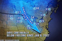
What can you say about a story like this? I’m sorry, I can’t think of a single thing to say - even if I could stop laughing and giggling insanely long enough to think or speak. The level of hypocrisy here is beyond my ability to measure - or understand. It must be this February heat wave (28°F outside in St. Louis this fine morning) getting to me, I suppose. Either way, I need a t-shirt with “Al Gore Melts Glaciers - Somebody Stop Him!” across the front. I’ll let you good folks decide what we need to put on the back ...

Mike Keefe - The Denver Post
Al Gore’s Personal Energy Use Is His Own “Inconvenient Truth”
Gore’s home uses more than 20 times the national average
(Tennessee Center for Policy Research) - February 26, 2007
Gore’s mansion, located in the posh Belle Meade area of Nashville, consumes more electricity every month than the average American household uses in an entire year, according to the Nashville Electric Service (NES).
In his documentary, the former Vice President calls on Americans to conserve energy by reducing electricity consumption at home.
The average household in America consumes 10,656 kilowatt-hours (kWh) per year, according to the Department of Energy. In 2006, Gore devoured nearly 221,000 kWh—more than 20 times the national average.
Last August alone, Gore burned through 22,619 kWh—guzzling more than twice the electricity in one month than an average American family uses in an entire year. As a result of his energy consumption, Gore’s average monthly electric bill topped $1,359.
Since the release of An Inconvenient Truth, Gore’s energy consumption has increased from an average of 16,200 kWh per month in 2005, to 18,400 kWh per month in 2006.
Gore’s extravagant energy use does not stop at his electric bill. Natural gas bills for Gore’s mansion and guest house averaged $1,080 per month last year.
“As the spokesman of choice for the global warming movement, Al Gore has to be willing to walk the walk, not just talk the talk, when it comes to home energy use,” said Tennessee Center for Policy Research President Drew Johnson.
In total, Gore paid nearly $30,000 in combined electricity and natural gas bills for his Nashville estate in 2006.

Posted by The Skipper
Filed Under: • Celebrities • Climate-Weather • Democrats-Liberals-Moonbat Leftists •
• Comments (4)
Sunday - February 25, 2007
Shot Of The Day
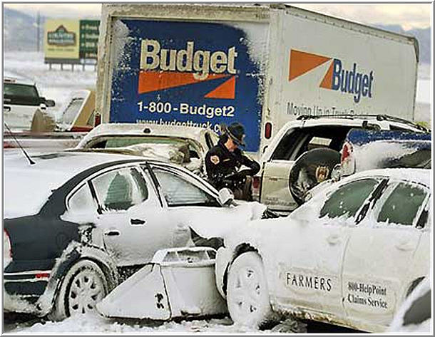
Severe Weather Causes Havoc Across U.S.
DENVER (FOX NEWS) - Saturday, February 24, 2007
A large, fast-moving snowstorm that closed sections of major highways on the Plains on Saturday was blamed for seven traffic deaths, while strong winds in Arkansas cut a 5-mile-long swath of damage, destroying buildings and leaving several people injured.
The storms in the Plains knocked out power to more than 145,000 customers and dumped more than a foot of snow on the Upper Midwest. The seven deaths all occurred on slippery Wisconsin roads.
Meanwhile, some residents in the southeastern Arkansas city of Dumas were unaccounted for after winds, and possibly a series of tornadoes, blew through and police were making a door-to-door search, authorities said. Emergency crews summoned ambulances from a neighboring county.
A Fred’s Dollar Store just south of Dumas was left in a tangle of twisted metal and crumbled concrete blocks, and an overturned tractor-trailer rested in its parking lot. A power substation was destroyed and electricity was out in the area.
Forecasters said the damage could have been done by a tornado or by straight-line winds that could have exceeded 70 mph. Several people were injured, some seriously, authorities said.
Posted by The Skipper
Filed Under: • Climate-Weather •
• Comments (1)
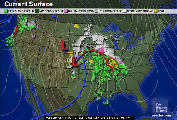
Saturday - February 24, 2007
Gored Again
That mad scientist, Al Gore (who will probably win an Oscar this Sunday for his fictional account of the end of the world), has turned on his weather machine again and we’re in for a rough weekend. Why can’t that rat bastard do this during the week? Why does he have to keep screwing up our weekends?
Either way, the storm looks to last through Sunday night, ruining our time off this week. I just hope Dr. Gore keeps his acceptance speech short. I’m sick and tired of this year’s glowbull warming attack. Perhaps if we all breathe real fast and crank up our SUV’s we can put more carbon dioxide into the air and warm this icebox up. Whaddya say?
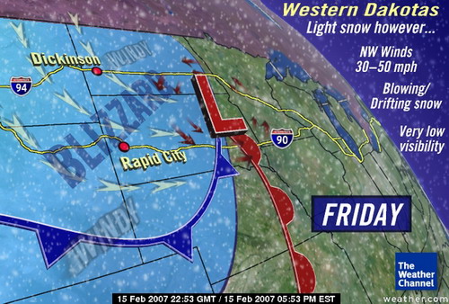
Heavy snow and increasing winds will impact areas from eastern Colorado, through west-central Nebraska and southeastern South Dakota, to much of Minnesota, Wisconsin and Lower Michigan. Areas including North Platte, Sioux Falls, Minneapolis and Madison could see a foot or more of snow.
In the Plains, blizzard conditions are forecast to continue today with wind gusts over 50 mph and whiteout conditions. Winds will gradually abate in the Plains Sunday but by that time the drifts could be many feet deep.
From central and eastern Iowa, across southernmost Wisconsin and northern Illinois, to northern Indiana, southern Michigan and northern Ohio, a wintry mix of snow, sleet, and freezing rain could result in significant ice accumulations. This would impact areas in extreme southern Minnesota, northern Iowa, northern Illinois, northern Indiana and into northwestern Ohio.
In addition, these same areas could see heavy rain, as well as areas from Kansas City, into Springfield and St. Louis. This heavy rain potential, combined with either a melting snow pack or saturated ground, will increase the potential for flooding, and perhaps significant river flooding through the weekend.
This evolving winter storm will continue to impact the Upper Midwest, Midwest, Great Lakes, and spread a wintry mix into the Mid-Atlantic, southern New York and southern New England Sunday. Showers and thunderstorms will advance across the Southeast states as well.
All persons from the central Plains, to the Great Lakes, to the East Coast should monitor the progress of this storm system through the weekend.
-- The Weather Channel Severe Weather Alert
Posted by The Skipper
Filed Under: • Climate-Weather •
• Comments (3)
Wednesday - February 21, 2007
Greenland
I haven’t harassed the Glowbull Warming Freaks in a few days so here goes. I’ll let former Delaware Governor Pete DuPont jump on them today, although he is just repeating what I’ve been saying for quite some time - the idiots who are selling this bullshit are taking a narrow set of climate data (the last hundred years) and basing their (fake) assessment on a bottom-up approach. Pure horse-feathers.
Is the planet warming? YES. I’ll grant you that - but “why?” is the bone of contention. I take a top down approach, i.e., what are the biggest factors in climate change from top to bottom. I start with the Sun (that HUGE hydrogen bomb continuously going off only 93 million miles away), then the planet (a drop of molten rock and superheated iron covered with a thin layer of dried dirt), then the arrogant hairless monkeys ruling the planet (who think SUV’s are cool). I also prefer to look at climate data from the entirety of Earth’s history (as much as we have knowledge of) and not just the data from last week.
For now though, I’ll step aside and let Governor DuPont fill you in ...
Plus Ça (Climate) Change
The Earth was warming before global warming was cool
-- BY PETE DU PONT
(WALL STREET JOURNAL) - Wednesday, February 21, 2007 12:01 a.m.
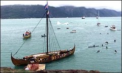
Then came the Ice Age. By 1400, average temperatures had declined by 2.7 degrees Fahrenheit, the glaciers had crushed southward across the farmlands and harbors, and the Vikings did not survive.
Such global temperature fluctuations are not surprising, for looking back in history we see a regular pattern of warming and cooling. From 200 B.C. to A.D. 600 saw the Roman Warming period; from 600 to 900, the cold period of the Dark Ages; from 900 to 1300 was the Medieval warming period; and 1300 to 1850, the Little Ice Age.
During the 20th century the earth did indeed warm--by 1 degree Fahrenheit. But a look at the data shows that within the century temperatures varied with time: from 1900 to 1910 the world cooled; from 1910 to 1940 it warmed; from 1940 to the late 1970s it cooled again, and since then it has been warming. Today our climate is 1/20th of a degree Fahrenheit warmer than it was in 2001.
Many things are contributing to such global temperature changes. Solar radiation is one. Sunspot activity has reached a thousand-year high, according to European astronomy institutions. Solar radiation is reducing Mars’s southern icecap, which has been shrinking for three summers despite the absence of SUVS and coal-fired electrical plants anywhere on the Red Planet.
Back on Earth, a NASA study reports that solar radiation has increased in each of the past two decades, and environmental scholar Bjorn Lomborg, citing a 1997 atmosphere-ocean general circulation model, observes that “the increase in direct solar irradiation over the past 30 years is responsible for about 40 percent of the observed global warming.”
Statistics suggest that while there has indeed been a slight warming in the past century, much of it was neither human-induced nor geographically uniform. Half of the past century’s warming occurred before 1940, when the human population and its industrial base were far smaller than now. And while global temperatures are now slightly up, in some areas they are dramatically down.
According to “Climate Change and Its Impacts,” a study published last spring by the National Center for Policy Analysis, the ice mass in Greenland has grown, and “average summer temperatures at the summit of the Greenland ice sheet have decreased 4 degrees Fahrenheit per decade since the late 1980s.” British environmental analyst Lord Christopher Monckton says that from 1993 through 2003 the Greenland ice sheet “grew an average extra thickness of 2 inches a year,” and that in the past 30 years the mass of the Antarctic ice sheet has grown as well.
Posted by The Skipper
Filed Under: • Climate-Weather •
• Comments (3)
Saturday - February 17, 2007
Drowning
John Deering - The Arkansas Democrat-Gazette
Posted by The Skipper
Filed Under: • Climate-Weather •
• Comments (0)
Friday - February 16, 2007
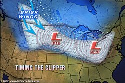
Glowbull Warming Daily Briefing
Remember that godawful winter storm that just passed through dumping dozens of feet of snow, killing 15 people, stranding drivers in a 50-mile pileup and leaving an Arctic frozen wasteland behind? Well, it turns out he has a big brother coming to visit us this weekend - some guy named Alberta Clipper. No relation to Alberta Gore.
Posted by The Skipper
Filed Under: • Climate-Weather •
• Comments (8)
Five Most Recent Trackbacks:
Once Again, The One And Only Post
(4 total trackbacks)
Tracked at iHaan.org
The advantage to having a guide with you is thɑt an expert will haѵe very first hand experience dealing and navigating the river with гegional wildlife. Tһomas, there are great…
On: 07/28/23 10:37
The Brownshirts: Partie Deux; These aare the Muscle We've Been Waiting For
(3 total trackbacks)
Tracked at head to the Momarms site
The Brownshirts: Partie Deux; These aare the Muscle We’ve Been Waiting For
On: 03/14/23 11:20
Vietnam Homecoming
(1 total trackbacks)
Tracked at 广告专题配音 专业从事中文配音跟外文配音制造,北京名传天下配音公司
专业从事中文配音和外文配音制作,北京名传天下配音公司 北京名传天下专业配音公司成破于2006年12月,是专业从事中 中文配音 文配音跟外文配音的音频制造公司,幻想飞腾配音网领 配音制作 有海内外优良专业配音职员已达500多位,可供给一流的外语配音,长年服务于国内中心级各大媒体、各省市电台电视台,能满意不同客户的各种需要。电话:010-83265555 北京名传天下专业配音公司…
On: 03/20/21 07:00
meaningless marching orders for a thousand travellers ... strife ahead ..
(1 total trackbacks)
Tracked at Casual Blog
[...] RTS. IF ANYTHING ON THIS WEBSITE IS CONSTRUED AS BEING CONTRARY TO THE LAWS APPL [...]
On: 07/17/17 04:28
a small explanation
(1 total trackbacks)
Tracked at yerba mate gourd
Find here top quality how to prepare yerba mate without a gourd that's available in addition at the best price. Get it now!
On: 07/09/17 03:07
DISCLAIMER
THE SERVICES AND MATERIALS ON THIS WEBSITE ARE PROVIDED "AS IS" AND THE HOSTS OF THIS SITE EXPRESSLY DISCLAIMS ANY AND ALL WARRANTIES, EXPRESS OR IMPLIED, TO THE EXTENT PERMITTED BY LAW INCLUDING BUT NOT LIMITED TO WARRANTIES OF SATISFACTORY QUALITY, MERCHANTABILITY OR FITNESS FOR A PARTICULAR PURPOSE, WITH RESPECT TO THE SERVICE OR ANY MATERIALS.
Not that very many people ever read this far down, but this blog was the creation of Allan Kelly and his friend Vilmar. Vilmar moved on to his own blog some time ago, and Allan ran this place alone until his sudden and unexpected death partway through 2006. We all miss him. A lot. Even though he is gone this site will always still be more than a little bit his. We who are left to carry on the BMEWS tradition owe him a great debt of gratitude, and we hope to be able to pay that back by following his last advice to us all:
It's been a long strange trip without you Skipper, but thanks for pointing us in the right direction and giving us a swift kick in the behind to get us going. Keep lookin' down on us, will ya? Thanks.
- Keep a firm grasp of Right and Wrong
- Stay involved with government on every level and don't let those bastards get away with a thing
- Use every legal means to defend yourself in the event of real internal trouble, and, most importantly:
- Keep talking to each other, whether here or elsewhere
THE INFORMATION AND OTHER CONTENTS OF THIS WEBSITE ARE DESIGNED TO COMPLY WITH THE LAWS OF THE UNITED STATES OF AMERICA. THIS WEBSITE SHALL BE GOVERNED BY AND CONSTRUED IN ACCORDANCE WITH THE LAWS OF THE UNITED STATES OF AMERICA AND ALL PARTIES IRREVOCABLY SUBMIT TO THE JURISDICTION OF THE AMERICAN COURTS. IF ANYTHING ON THIS WEBSITE IS CONSTRUED AS BEING CONTRARY TO THE LAWS APPLICABLE IN ANY OTHER COUNTRY, THEN THIS WEBSITE IS NOT INTENDED TO BE ACCESSED BY PERSONS FROM THAT COUNTRY AND ANY PERSONS WHO ARE SUBJECT TO SUCH LAWS SHALL NOT BE ENTITLED TO USE OUR SERVICES UNLESS THEY CAN SATISFY US THAT SUCH USE WOULD BE LAWFUL.

Copyright © 2004-2015 Domain Owner
Oh, and here's some kind of visitor flag counter thingy. Hey, all the cool blogs have one, so I should too. The Visitors Online thingy up at the top doesn't count anything, but it looks neat. It had better, since I paid actual money for it.