Local Stories
http://en.wikipedia.org/wiki/Lehigh_Valley_Railroad
http://en.wikipedia.org/wiki/File:Easton_and_Amboy_Railroad.svg
http://www.flickr.com/photos/kevinhooa/2101626001/sizes/o/in/set-72157603869976680/
http://www.flickr.com/photos/kevinhooa/2101625049/sizes/l/in/set-72157603869976680/
http://www.flickr.com/photos/kevinhooa/4161455739/sizes/l/in/set-72157603869976680/ - nothing left but fog
http://westjerseyhistory.org/images/hunterdon/bellwoodpark/ - historic pictures of Bellwood Park
tunnel GPS coordinates for Bing.com/maps or Google Maps:
East side 40.641711, -75.021476, 3/4m NW of Pattenburg Rd
West side 40.65266,-75.031883 100 yards W of where Tunnel Rd meets Ridge Rd
Pull up a map and notice the discontinuity on Bellwood Park Rd: the road is closed across the peak because the ground is broken.
RR history in the USA. Look where it started up big: coal to Philly and NYC: http://en.wikipedia.org/wiki/Timeline_of_United_States_railway_history
http://en.wikipedia.org/wiki/Camden_and_Amboy
http://en.wikipedia.org/wiki/Belvidere_Delaware_Railroad
http://en.wikipedia.org/wiki/Delaware_and_Hudson
a map: http://upload.wikimedia.org/wikipedia/commons/4/4d/1886_D%26H.jpg yes, there really is a place called Manunka Chunk NJ, but Mauch Chunk is in PA.
http://www.switchbackgravityrr.org/
http://explorepahistory.com/hmarker.php?markerId=1-A-1C7
http://www.portjervisny.com/fr-dhcanal.htm
History is all around you. Sometimes it’s next to you, sometimes it’s right in front of you. Sometimes you’re standing right on top of it, and never even know.
This is pretty much the same spot, a few miles to the west of me, separated by 100 years and about 100 vertical feet:
Once upon a time, when America was young and able and believed in itself and got things done because it didn’t know how not to, New Jersey really was a back water state. Aside from a couple of nice colonial towns and a few cobblestone “highways”, the whole state was a forest, with isolated little farms and mines here and there. And nothing between them but dirt paths through the woods, hardly better than deer tracks.
But there was a demand for goods and services from elsewhere. And there was a demand to be able to get through this state in as short a time as possible. So the state came up with this nice little money maker called a charter. They chartered highways: for a certain amount of money, they’d sell you the right to run a toll road between this place and that place, and you could collect whatever you could as long as you kept the roads open. They didn’t make it. We had toll roads all over the place, called turnpikes, but we also soon had the NJ creation called a “shunpike” ... a sneak around the toll house so you wouldn’t have to pay. The chartered highways soon failed.
We had chartered canals too. Several of them. For a couple of decades they were a great idea, because the toll roads were never in good condition and horse drawn wagons just couldn’t move the amount of cargo that canal boats could. But like the Pony Express delivering coils of wire for some guy named Samuel Morse, the canals carried the seeds of their own destruction; the very first one opened in the Delaware Valley carried a little steam engine imported from England and some iron tracks. The Stourbridge Lion, the first steam locomotive in the USA, went to the coal fields in PA in 1829 by canal.
The demand for produce and hard coal in Philadelphia and New York City was insatiable, so railways proliferated. Even the canals kept busy for 70 years. But trains were the future and everyone knew it.
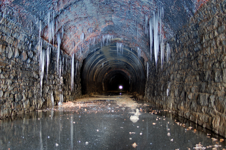
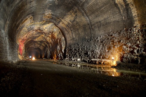
I can’t begin to understand the various rights of way and the linage and trackage and all that choo-choo stuff, but New Jersey soon had dozens of railroads operating here. One of those early rail companies, actually a conglomerate of two earlier lines, the Easton & Perth Amboy Railroad, drove their tracks eastward across the state from the Delaware Valley, and tunneled right through Musconetcong Mountain. The same mountain that the locals today call Jugtown Mountain. The same one that carries a highway steep enough and twisty enough that I preferred not to face it in my little wind up rented Chevy Spark. And underneath me that whole time was a train tunnel, from 1872.
Jugtown Mountain is the southern end of a ridge that runs across the central western part of the state, called the Highlands. From the top of the mountain you can see a long long way. So when the tunnel was done, after the drownings and the race riots, and the new national record was set, the owners came out of the eastern terminus and saw what a great view there was. And decided to make money off of that.
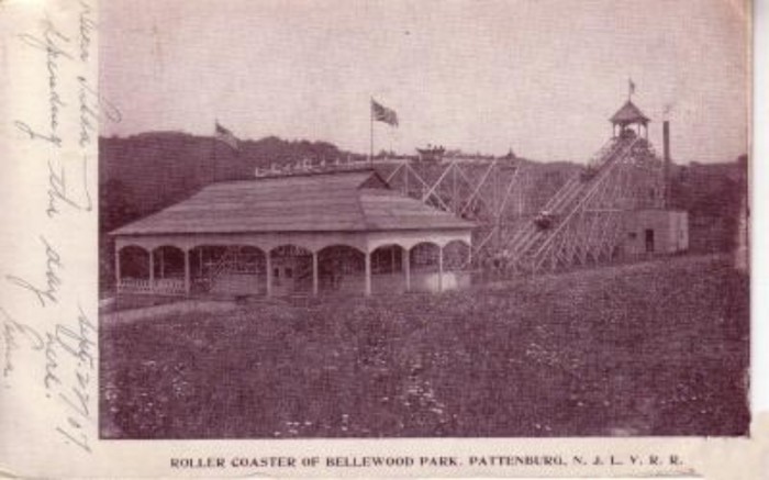
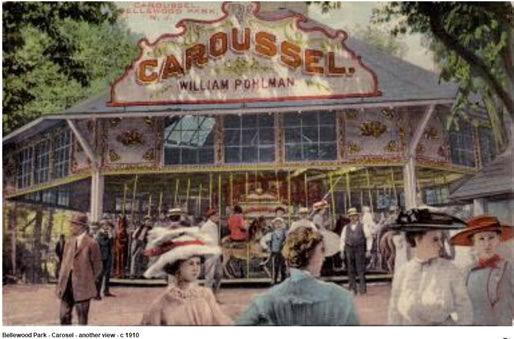
[The new tunnel is about 25 yards to the south of the old one. It’s taller and wider, and when the trains pass through it at night and blow their horns you can hear it all the way across the county]The Pattenburg Tunnel, or Musconetcong Tunnel as it was more commonly known when it was built, was constructed from 1872 to 1875. It was bored through Jugtown mountain as the locals called it by the Easton and Amboy RR and was 4,893 feet long when completed. It was actually the longest tunnel constructed on the east coast until the Hoosac Tunnel was finished in Massachusetts around 1876. This huge project was constructed under the supervision of Henry Drinker who, at the time of the start of construction, was only 21 years of age. Construction was not easy for the young Lehigh University graduate and several large obstacles were met with difficulty along the way. In May of 1873 a very large underground aquifer was struck with an pneumatic drill which resulted in huge burst of water and severe flooding. Before the water could be entirely pumped out it destroyed several of the wooden support arches in place to hold the masonry work. This now empty underground chamber can still be seen today by walking 1/4 mile in from the west portal and shining a very bright light up at the ceiling. After things were eventually cleaned up the tunnel soon hit another obstacle many other business and industries ran into around that time - the panic of 1873. Another large problem was with the workers who were largely responsible for the construction of the tunnel. Long hours, exhaustion, race issues, and alcohol were responsible for a large number of fights with one in November of 1872 resulting in 5 deaths and many other injuries. Despite many setbacks and troubles, the Musconetcong Tunnel was finally holed through in Dec of 1874 and later opened in June of 1875. Eventually the Easton and Amboy RR was absorbed by the Lehigh Valley RR who decided later to build a vacation resort on the eastern side of the tunnel. Bellwood Park as it was called, was a popular place for traveling folks from PA to NYC to visit in the summer months. The park featured many rides including a roller coaster and a ferris wheel, however it later closed in 1916. Although this tunnel was a marvel in engineering at it’s time of completion, it constantly had water problems and was a little small for the newer locomotives in the early 20th century. A larger, better tunnel was constructed by the Lehigh Valley RR and opened in November of 1928. Although the tracks have been slightly modified in the tunnel, it still sees several trains a day from Norfolk Southern.
So above their leaky tunnel ... their possibly unstable tunnel, because no one had told the railroad that the mountain had been mined for iron ore for the past 100 years or more ... they built a theme park. Because the rail carried coal Monday to Friday, so they needed to make money on the weekends. So they put in a passenger line, built an amusement park, and brought folks in from New York City and from Easton PA. And they arrived by the thousands. To sleepy little Bethlehem Township. Unreal. Even if their roller coaster was only 50 feet high, the view from the top must have been fantastic. You could almost see across the entire state on a clear day, and easily see halfway to Philadelphia.
July 4, 1904. Opening Day at Bellewood Park brought more than 10,000 people to the amusement park in Pattenburg. Most families came by train, from the Lehigh Valley terminus at Allentown, Pa. to the west and Jersey City and New York City to the east.
Farm families from within Hunterdon County boarded the trains at local stops, such as Flemington and Clinton, or arrived by horse and wagon. Railroad sidings were constructed to accommodate the traffic and the park operated from Memorial Day to mid-October. Thousands arrived every day except Monday, but mostly on the weekends.
The Lehigh Valley Railroad hoped to supplement its income from the tracks, used mostly for hauling coal west to east during the week, with weekend excursion fares. The park proved an immediate success. The main attraction was the beauty of the area—the Musconetcong Mountain offered a panorama of rolling hills, flower beds bloomed throughout the park and picnic areas were available near babbling brooks and under shady trees.
So they made extra cash for a decade, and then closed the joint when business started to fade, taking away every building, board, and scrap.
For the more adventuresome and eager the park offered a wide variety of activities—a dance pavilion, boat rides, a roller coaster, a German beer garden, a shooting gallery, a bowling alley, a carousal, a Ferris Wheel, a fun house, a Tunnel of Love and a penny arcade. A photo studio was also on the grounds.
President Teddy Roosevelt stopped at Bellewood Park in 1905 and mixed with 6,000 people there that day, mostly from religious groups. On any given day, the park attracted Grand Army groups (Civil War veterans’ associations), church groups, ethnic groups and singing societies for outings.
Despite its success, Bellewood Park closed in October 1916 after a 12-year run.
Pretty hard to believe, as Pattenburg doesn’t have a population of 500 these days I think, unless you’re taking a much bigger unincorporated township area under consideration. And then there was the mining disaster in 1989…
When chunks of granite from a nearby quarry tumbled into his backyard last spring, Gus Dobes of Bethlehem Township complained to the state. Months earlier, when he and his neighbors noticed that their houses were shaking more than usual from the quarry’s blasts, he signed a petition that was also sent to the state.
Now that Mr. Dobes has lost at least an acre of his backyard to a 60-foot-deep chasm that he thinks was created by unsafe mining by the owners of the Pattenburg Quarry, he has opted for a different strategy. ‘’I think I will have the lawyer do the talking,’’ he said. For Mr. Dobes, who has lived for 20 years in the same house, which is roughly 400 feet from the quarry, the story is pretty simple: a crack in the road outside his door in late October, a blast of dynamite in the quarry in early November and then, 20 minutes later, a 250-foot-long landslide that swallowed some of his land.
And if you look at a map, you’ll see the landslide in the quarry is just a short distance down hill from the eastern end of that 1873 railroad tunnel, the one that always had the water leakage problems for 115 years before the slope gave way with some dynamite help.
History everywhere. And 150,000 cars and trucks a day clamber up the highway over Jugtown Mountain and down the other side, bound for parts east or west at 80mph, and never know what they just drove past.
Words do fail Drew.
One of the best posts I’ve seen. But then, I’m a sucker for this kind of history.You should have pinned it to the top for 24 hours.
Very well written needless to say.
One little niggly thing. Re Pattenburg tunnel, should that line about a fight and five deaths be dated 1872?
Curious, what made you land on this subject? I take it you’ve always been aware of it.
Is that right?
Hell of a good post and thanks.Posted by peiper 09/28/2012 at 05:01 AM

Yes it should. I fixed it. I had just snagged the text from that page on Flickr.
Like I wrote, I go over that mountain all the time, as do hundreds of thousands of others.
You can Bing or Google “jugtown mountain tunnel” “bellwood tunnel” “bellewood tunnel” “musconetcong mountain tunnel” and get back piles of images. People have been getting a thrill there for ages now.
I’ve only recently “discovered” the area myself; the northwestern corner of Hunterdon County and it’s neighbor the southwestern corner of Warren County are more than just a little off the beaten track, and that’s relative to the rural-ity around here. Yet they have their own rich history, which peaked in the Colonial to Victorian periods, and then the area went back to sleep.
Sure, it pales compared to your neighborhood, Mr. Bronze Age Ruins At The End Of My Street, but nearly everything including those Johnny-Come-Lately pikers in Cairo Egypt. But for the USA, to have mills still standing - still functional even - that ground flour for George Washington’s troops, to have the iron forges that made him cannonballs, and to have buildings and bridges from that era to the immediate post-Civil War era is pretty amazing. Most of early American was made out of wood, and wood doesn’t last. Plus we have the seeds of the Industrial Revolution here, and also those of nascent capitalism, with the canals of the 1830s (can you imagine Jim Fink, King of the Raritan River in NJ??) and the coal trade, plus the loggers before that- Paul Bunyan, not somewhere far up north, but on the wild Indian frontier ... of the Delaware River.
And we do have some seriously funky bridges here too.
Posted by Drew458 09/28/2012 at 07:52 AM

I used to live a stone’s throw away in Washington. It was a great place to be a kid, circa 1964.
Posted by Steve_in_CA 09/28/2012 at 08:32 AM
You should see Washington today! ... hasn’t changed a bit really, except the gas station on the corner of Rt 57 is now a LukOil.
Posted by Drew458 09/28/2012 at 02:56 PM
The last time I visited there was in 1986. The “downtown” seemed pretty run down from what I remember. But when you’re a kid, everything seems to be fresh and new. From google maps, my old house on W. Warren St. was still there, but boy what a build up of houses. The farms I
vandalizedroamed through are all gone.Posted by Steve_in_CA 09/28/2012 at 03:07 PM
Commenting is not available in this weblog entry.
Next entry: some eye candy sort of
Previous entry: Even With Diagrams, Nobody Will Listen