Saturday - October 22, 2005
Yabba-Dabba-Doo
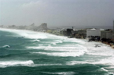
Wilma Rips Cancun
CANCUN, Mexico (AP)
Ocean waves surged over the narrow strip of land holding Cancun’s resort hotels Saturday as Hurricane Wilma crawled over Mexico’s Yucatan Peninsula, keeping some 30,000 tourists huddled in hotels and shelters amid shrieking winds and shattering glass.
The slow advance of the storm, which killed 13 people in Haiti and Jamaica last week, gave Florida more time to prepare but meant another day of misery for people riding out 120 mph winds and flooding in hot, leaky shelters with little food and water.
After battering Cozumel Island with 140 mph winds Friday, Wilma came ashore overnight near Playa de Carmen in a sparsely populated area of luxury resorts about 30 miles south of Cancun and creeped toward this city, weakening to a Category 3 storm.
The storm was expected to pummel the tip of Yucatan all day Saturday before moving into the Gulf of Mexico, curling around Cuba’s western end and sprinting toward Florida for an expected landfall Monday.
In Florida, residents began leaving the Keys and parts of the mainland Friday. Scattered gasoline shortages were reported and traffic jams backed up highways as people fled Florida’s west coast.
Winds caused severe damage in Playa de Carmen, flattening dozens of wood-and-tarpaper houses and tossing rooftop water tanks and wooden window coverings through the air. Communications were cut off with Cozumel, a popular cruise ship destination 11 miles offshore. Damage was intensified by the storm being nearly stalled atop Yucatan since Friday.
- More On This Story Here
Posted by The Skipper
Filed Under: • Climate-Weather •
• Comments (3)
Wednesday - October 19, 2005
Flintstoned
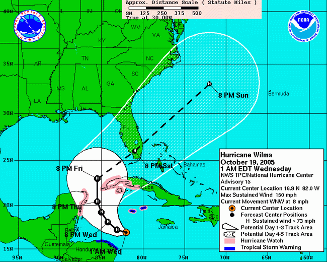
AT 2 AM EDT...0600Z...THE CENTER OF HURRICANE WILMA WAS LOCATED NEAR LATITUDE 17.0 NORTH...LONGITUDE 82.2 WEST OR ABOUT 170 MILES… 270 KM...SOUTH-SOUTHWEST OF GRAND CAYMAN AND ABOUT 400 MILES...640 KM...SOUTHEAST OF COZUMEL MEXICO.
WILMA IS MOVING TOWARD THE WEST-NORTHWEST NEAR 8 MPH...13 KM/HR. A TURN TOWARD THE NORTHWEST IS EXPECTED DURING THE NEXT 24 HOURS.
MAXIMUM SUSTAINED WINDS ARE NEAR 150 MPH...240 KM/HR...WITH HIGHER GUSTS. WILMA IS AN EXTREMELY DANGEROUS CATEGORY FOUR HURRICANE ON THE SAFFIR-SIMPSON SCALE. THE HURRICANE COULD BECOME A CATEGORY FIVE HURRICANE TODAY.
HURRICANE FORCE WINDS EXTEND OUTWARD UP TO 15 MILES...30 KM… FROM THE CENTER...AND TROPICAL STORM FORCE WINDS EXTEND OUTWARD UP TO 155 MILES...250 KM. NOAA BUOY 42057 RECENTLY REPORTED A WIND GUST TO NEAR 60 MPH...96 KM/HR.
LATEST MINIMUM CENTRAL PRESSURE JUST REPORTED BY AN AIR FORCE RECONNAISSANCE PLANE WAS IS 901 MB...26.61 INCHES.
http://www.nhc.noaa.gov/
Posted by The Skipper
Filed Under: • Climate-Weather •
• Comments (2)
Monday - October 17, 2005
Guess What?
Another storm is brewing in the Caribbean. Guess what that is causing ....?
Go ahead and guess ...?
Give up ...?
You won’t believe this ....
No one could have predicted it ....
SURPRISE ...!!
Oil Prices Rise as Another Storm Brews in Caribbean
NEW YORK (AP)
Crude-oil futures rose Monday on concerns that a tropical storm in the Caribbean could grow into a hurricane and threaten Gulf of Mexico oil facilities still recovering from previous hurricanes. Analysts said prices also received support from weekend unrest in Iran - OPEC’s second-largest producer of crude - and mixed signals on spare capacity from members of the Organization of Petroleum Exporting Countries.
Estimates from OPEC of sagging world demand growth contained in its monthly oil market snapshot seemed to have little immediate effect. Light, sweet crude for November delivery rose 97 cents to $63.60 a barrel in midday trading on the New York Mercantile Exchange. December Brent futures on the International Petroleum Exchange in London rose 93 cents to $60.41 a barrel. Products also jumped. Heating oil gained 2 cents to $1.97 a gallon on the Nymex, while gasoline rose by 2.14 cents to $1.77 per gallon. Natural gas rose 52 cents to $13.74 per 1,000 cubic feet.
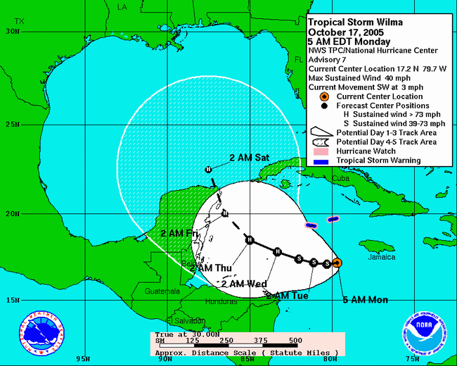
Tropical Storm Wilma formed south of the Cayman Islands on Monday as the 21st named storm of the season, tying the 1933 record for the most storms in an Atlantic season, the National Hurricane Center in Miami said. At 11 a.m. EDT, Wilma had top sustained wind near 45 mph, up 5 mph from earlier in the day, the National Hurricane Center said. It was centered about 220 miles south-southeast of Grand Cayman. Long-term forecasts show the storm heading into the Gulf of Mexico by the weekend. Experts said high water temperatures and other conditions meant it could become a significant hurricane.
Posted by The Skipper
Filed Under: • Climate-Weather •
• Comments (13)
Not Again!
Mother nature isn’t through with us just yet. Tropical storm Wilma is forming in the Gulf and will reach hurricane strength by Wednesday as it takes aim at (guess where?) New Orleans. This ties the record for most hurricanes in a single season. Of course, you all realize it’s time to fire up the Democratic Party chorus and sing another verse of “It’s Bush’s Fault” ...
Posted by The Skipper
Filed Under: • Climate-Weather •
• Comments (24)
Saturday - September 24, 2005
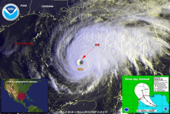
Rita Update
Rita Slams Ashore at Tex.-La. Border
(WASHINGTON POST)
Hurricane Rita stormed into Texas and Louisiana at 3:30 A.M EDT, with relentless winds of 120 MPH, sheets of rain and battering waves that flooded coastal communities, uprooted trees and tore apart numerous buildings. Damage reports were scarce at daybreak. But officials said the heavily populated area from Houston to Galveston was in relatively good shape, with blown-out windows in some highrise buidlings, widespread power outages, limited flooding and fires in Galveston being the major issue.
As Hurricane Rita bears down on the Gulf Coast, residents evacuate and local and national officials prepare for the coming storm. Towns hit more heavily, according to first accounts, included Beaumont, Lumberton and Port Arthur in Texas and the area around Lake Charles in Louisiana. Authorities stressed that Rita was continuing to rage, however, in this region’s season of epic weather woe.
The storm, though weakened from a category 3 to a category 2 by friction with land, appeared to be preparing for a mean march inland, all the more damaging because of its slow pace, which could produce as much as 25 inches of rain along the way. Eight inches had already fallen by 8:00 A.M. EDT in cities and towns such as Beaumont. Among the threatened areas was metropolitan New Orleans, where flooding continued Saturday after water gushed over the top of some of the city’s levees.
There were reports of major damage to the Lake Charles, La., airport, the collapse of an overpass on Interstate 110 near Lake Charles, a loose barge in the Houston shipping channel and power lines down across the entire region. A spectacular fire engulfed three buildings in Galveston’s historic downtown and another building collapsed in the same area as Rita raked the island city.
“We have trees across roads. In downtown we have observed several businesses totally destroyed,” Sulphur, La., police department spokesman George Mullican told the Associated Press. “It’s too dangerous to send anyone out right now because of the wind.” In Rita’s path were many of the nation’s largest refineries, but their fate was not yet known. Ed Rappaport, of the National Hurricane Center, said that a storm surge between 5 to 10 feet will remain a concern throughout the day especially to the east of the storm’s center at the Texas-Louisiana border near Sabine Pass, La., and Port Arthur, Tex.
Posted by The Skipper
Filed Under: • Climate-Weather •
• Comments (1)
Friday - September 23, 2005
Rita Bits
- Water Over The Levees: New Orleans Is Flooding Again
- Evacuation Bus Bursts Into Flames: 24 Elderly Retirees Dead
- Houston Airport Jammed: Delays Due To TSA Screeners Not Coming To Work
- Airlines Sending More Planes To Houston To Help Evacuate: Also Doubling Price Of Tickets Due To Pure Greed
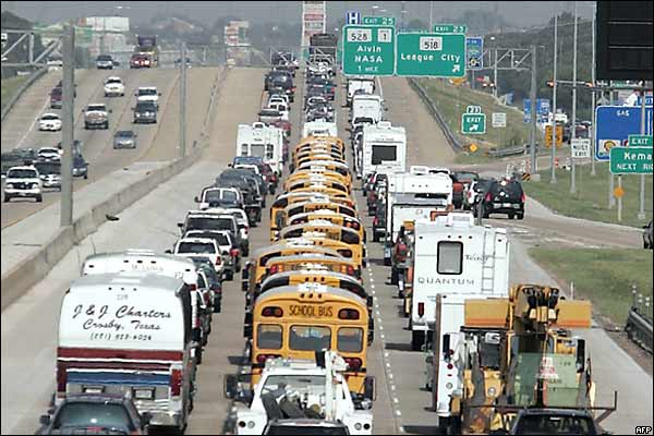
- I-45 Out Of Houston Is Still A Parking Lot, Traffic Moving At 3 mph: Many Cars Already Running Out Of Gas
- Rita May Miss Galveston, Houston: Port Arthur and Beaumont Are Toast
- On News That Rita Will Miss Houston Oil Prices Fell By $1 Per Barrel
Posted by The Skipper
Filed Under: • Climate-Weather • News-Briefs •
• Comments (13)
Photos From Galveston

Photos courtesy of the BBC, AFP & Getty Images.
Posted by The Skipper
Filed Under: • Climate-Weather •
• Comments (8)
Houston, You Have A Problem …
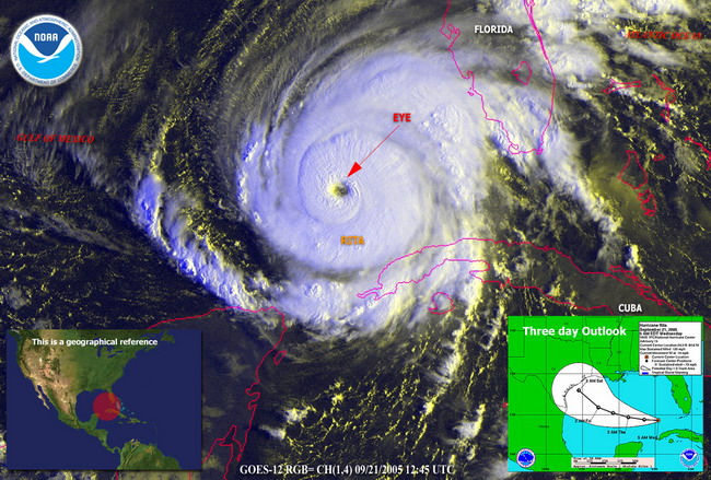
National Hurricane Center Bulletin:
AT 1 AM CDT...0600Z...THE CENTER OF HURRICANE RITA WAS LOCATED NEAR LATITUDE 26.4 NORTH… LONGITUDE 90.6 WEST OR ABOUT 325 MILES… 525 KM… SOUTHEAST OF GALVESTON TEXAS AND ABOUT 285 MILES… 460 KM...SOUTHEAST OF CAMERON LOUISIANA. RITA IS MOVING TOWARD THE WEST-NORTHWEST NEAR 10 MPH...17 KM/HR. A GRADUAL TURN TOWARD THE NORTHWEST IS EXPECTED DURING THE NEXT 24 HOURS. ON THIS TRACK...THE CORE OF RITA WILL BE APPROACHING THE SOUTHWEST LOUISIANA AND UPPER TEXAS COASTS LATE FRIDAY.
REPORTS FROM AN AIR FORCE RESERVE HURRICANE HUNTER AIRCRAFT INDICATE THAT MAXIMUM SUSTAINED WINDS REMAIN NEAR 140 MPH...220 KM/HR...WITH HIGHER GUSTS. RITA IS AN EXTREMELY DANGEROUS CATEGORY FOUR HURRICANE ON THE SAFFIR-SIMPSON SCALE. SOME FLUCTUATIONS IN STRENGTH ARE EXPECTED DURING THE NEXT 24 HOURS.
HURRICANE FORCE WINDS EXTEND OUTWARD UP TO 80 MILES...130 KM… FROM THE CENTER...AND TROPICAL STORM FORCE WINDS EXTEND OUTWARD UP TO 205 MILES...335 KM. ANY TROPICAL STORM FORCE WINDS IN THE NEW ORLEANS AREA ARE EXPECTED TO BE CONFINED TO A FEW SQUALLS ASSOCIATED WITH QUICKLY MOVING RAINBANDS. THE LATEST MINIMUM CENTRAL PRESSURE REPORTED BY AN AIR FORCE HURRICANE HUNTER AIRCRAFT WAS 921 MB...27.20 INCHES.
COASTAL STORM SURGE FLOODING OF 15 TO 20 FEET ABOVE NORMAL TIDE LEVELS...ALONG WITH LARGE AND DANGEROUS BATTERING WAVES...CAN BE EXPECTED NEAR AND TO THE EAST OF WHERE THE CENTER MAKES LANDFALL. TIDES ARE CURRENTLY RUNNING ABOUT 2 FEET ABOVE NORMAL ALONG THE LOUISIANA...MISSISSIPPI AND ALABAMA COASTS IN THE AREAS AFFECTED BY KATRINA. TIDES IN THOSE AREAS WILL INCREASE TO 3 TO 5 FEET AND BE ACCOMPANIED BY LARGE WAVES...AND RESIDENTS THERE COULD EXPERIENCE COASTAL FLOODING.
Posted by The Skipper
Filed Under: • Climate-Weather •
• Comments (5)
Thursday - September 22, 2005
Public Service Announcement
Alright, people! Listen Up! Let’s get it right this time!
Federal Emergency Management Agency (FEMA): 1-800-621-FEMA (1-800-621-3362)
TEXAS:
Texas Division of Emergency Management
5805 N. Lamar
Austin, Texas 78752
(512) 424-2138
(512) 424-2444 or 7160 FAX http://www.txdps.state.tx.us/dem/
KHOU Houston Storm Updates & Phone Numbers: http://www.khou.com/
Brazoria County, TX:
If you need a ride out of Brazoria County and need information info:
Lake Jackson Intermediate School—(979) 415 2700
Clute Intermediate School—(979) 265 2082
Freeport Intermediate School—(979) 265 3953
Galveston County, TX:
Information on Galveston evacuation: (409) 797-3710
To get a cage to take on the bus (and only if you are riding the bus): (409) 763-8477
To register to ride the bus: (409) 797-3510
If you need an ambulance to evacuate: (409) 938-2424
Spanish evacuation help line: (713) 881-3100
TDD help line: (713) 881-3099
Brazos animal shelter that only accepts healthy pets: (979) 775-5755
LOUISIANA:
Louisiana Office of Emergency Preparedness
7667 Independence Blvd.
Baton Rouge, Louisiana 70806
(225) 925-7500
(225) 925-7501 FAX
http://www.ohsep.louisiana.gov
State Police Road Closure Hotline: 1-800-469-4828
Red Cross- 1(866)-GET-INFO (438-4636)
Special Needs Shelter Information
Triage Phone Numbers:
Alexandria: 800-841-5778
Shreveport: 800-841-5776
Baton Rouge: 800-349-1372
Monroe: 866-280-7287
Houma/Thibodaux: 800-228-9409
Slidell/Hammond: 985-871-1300
Lafayette: 800-901-3210
Lake Charles: 866-280-2711
Louisiana Hotel Information 1-800-99-GUMBO
Emergency Shelter Information Points:
Tourist Welcome Center, US 65 & 84, 1401 Carter St. (US 84), Vidalia, LA
Tourist Welcome Center, TA Truck Stop, Tallulah Exit (Hwy 65 & I 20)
Paragon Casino, 711 Paragon Place, Marksville LA
Sammy’s Truck Stop, I-49, Exit 53, 3601 LA 115W, Bunkie, LA
Med Express Office, 7525 US 71, Alexandria, LA
P.E. Gym, LSU- Shreveport, One University Place, Shreveport, LA
Pickering High School, 180 Lebleu Rd., Leesville, LA
Mowad Civic Center, 5th & 10th St., 1 Block off US 165, Oakdale, LA
Posted by The Skipper
Filed Under: • Climate-Weather •
• Comments (16)
Red Sky At Morning
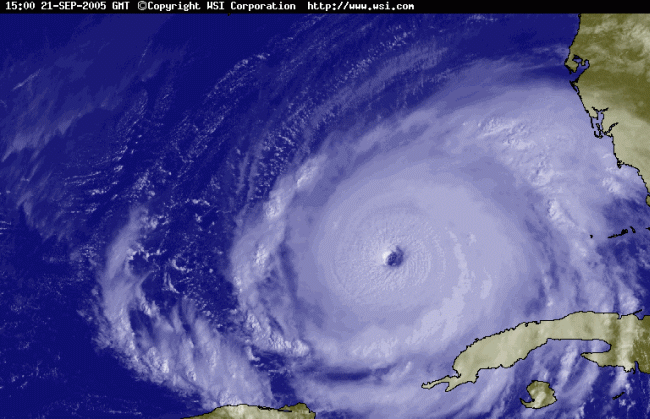
I’ve made note here before that my vast (and really unwanted) experience with hurricanes, which comes from living on the Gulf Coast most of my life, has always taught me that the surest sign of a really bad one is how fast the barometer drops below 1000 mb and heads down toward 900 mb. Unfortunately, I have no frame of reference for what happens when the mercury drops below 900 mb. Much less this fast. Rita just passed through the Florida Keys yesterday as a Category 2 hurricane and suddenly went ape-shit. Inside the eye the bottom dropped out of the barometer and is currently (3:00am ET) at 898 mb and still falling. Maximum sustained winds are already at 175 mph with gusts up to 220 mph. On the Saffir-Simpson scale, that makes Rita a really, really bad Category 5 hurricane.
I have my own hurricane rating system. It’s called The Pucker Factor. I rank the storms by how tightly my sphincter contracts when I think about what is coming. Right now my butt is chewing a hole in my chair. I’d say that’s a “Pucker Factor” of +8 or higher. For reference, I’ve only recorded this high a reading once in my life .. on a camping trip to the Great Smokey Mountains in 1985 when our camp was invaded by a large brown bear in the dead of night. What makes it worse is that I’m currently living in St. Louis and I’m still getting a high reading. This bodes ill.
My advice to anyone on the Texas coast is .... get in your car and drive West at high speed - don’t slow down until you hit Albuquerque. Just do it! Now!
One final note: if anybody out there even mentions “global warming” over the next seventy-two hours, I will personally take a #14 ClueBat to your headbone and beat some sense into your damaged brain. The Texas coast is a nicely curved smooth arc for a very good reason. Unlike Norway (which never gets hurricanes and has all kinds of rough jiggly bits sticking in and out along its coast), the Gulf Coast has been worn smooth in nice little arcs by tens of thousands of years of repeated attacks from hurricanes. It ain’t nothing new. Get over it!
Get the latest updates at The National Hurricane Center!
Posted by The Skipper
Filed Under: • Climate-Weather •
• Comments (19)
Wednesday - September 21, 2005
Snugged Down and Waiting
Jim at Smoke on the Water just signed off.......for now.
Thank you all, each and every one! That is all I can do now, for it is time for me now to take leave of my beloved home, to trust her to the hand of God, and the to the will and the effort I have invested to keep her safe against the storm.
I shall drive away, unwillingly. But drive I must, if only to not subject the pure love of my two cats to the hell that is due to descend upon these docks in but thirty-six hours time.
My course is uncharted, the waters strange and the waves of patterns yet to be learned.
But I will sail into this future determinedly. It is the only future I have, it is the only course I can sail.
May God be with you, and the Sloop New Dawn
Posted by Drew458
Filed Under: • Climate-Weather • News-Briefs •
• Comments (2)
Now She’s a “4”
(Image via Intellicast)
Laurence Simon has a roundup of Texas bloggers who are covering the storm.
Gonna be another nasty one.
Posted by Drew458
Filed Under: • Climate-Weather •
• Comments (8)
Another Monster Grows
KEY WEST, Fla. (AP)
Hurricane Rita strengthened into a Category 3 storm packing 120 mph winds as it churned into the Gulf of Mexico early Wednesday, deepening concerns that the storm could target Texas and already-battered Louisiana by week’s end. Forecasters warned that the storm could further intensify, sparking an order for mandatory evacuations in New Orleans and Galveston, Texas. Homeland Security Secretary Michael Chertoff urged residents to heed calls for evacuation Wednesday.
“The lesson is that when the storm hits, the best place to be is to be out of the path of the storm,” he told ABC’s “Good Morning America.” “There’s plenty of (advance) notice about Rita.” Acting FEMA Director R. David Paulison said the agency has aircraft and buses available to evacuate residents of areas the hurricane might hit. Rescue teams and truckloads of ice, water and prepared meals were being sent to Texas and Florida. “I strongly urge Gulf coast residents to pay attention” to the storm, he said.
Stung by criticism of the government’s slow initial response to Hurricane Katrina, President Bush signed an emergency declaration for Florida and spoke with Texas Gov. Rick Perry about planning for the storm’s landfall. Perry said Texans are taking the warnings seriously. “I think Texas is prepared as any state in the nation,” he told NBC’s “Today” show Wednesday. Rita created relatively few problems along the Florida Keys, where thousands of relieved residents who evacuated are expected to begin returning in earnest on Wednesday.
During daytime hours, several stretches of the Keys highway, U.S. 1, were barricaded because of water and debris; by nightfall, only one small problem area remained and the entire highway was passable, the Florida Highway Patrol said. There were reports of localized flooding, and some sections of the Lower Keys were still without power early Wednesday. But the storm’s raging eye did not hit land. “It was fairly nothing,” said Gary Wood, who owns a bar in Marathon, about 45 miles northeast of Key West. “It came through and had a good stiff wind, but that was about it.”
In Key Colony Beach, an oceanfront island off Marathon, Mayor Clyde Burnett said a restaurant and hotel were damaged by water and wind, but that widespread problems simply didn’t arrive as expected. Visitors ordered out of the Keys will be invited back Friday, and virtually all other voluntary evacuation orders in South Florida were lifted after Rita roared past. Now, all eyes following Rita are turning toward the Gulf—where the hurricane is causing new anxiety among Katrina victims in Mississippi, Louisiana and Alabama.
At 5 a.m. EDT, Rita’s eye was about 175 miles west of Key West. The storm was moving west at 14 mph—a track that kept the most destructive winds at sea and away from Key West. Maximum sustained winds increased to near 120 mph. “There’s still plenty of warm water that it needs to move over in the next couple days. The forecast is favorable for further intensification,” said Michelle Mainelli, a meteorologist at the National Hurricane Center.
Posted by The Skipper
Filed Under: • Climate-Weather •
• Comments (8)
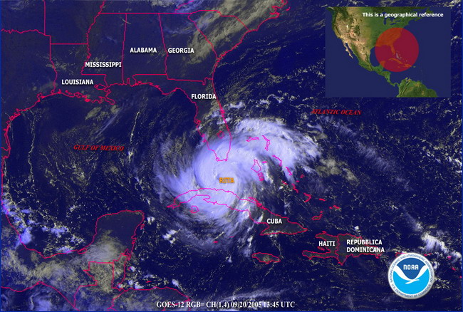
Tuesday - September 20, 2005
BOHICA
Posted by The Skipper
Filed Under: • Climate-Weather •
• Comments (3)
Five Most Recent Trackbacks:
Once Again, The One And Only Post
(4 total trackbacks)
Tracked at iHaan.org
The advantage to having a guide with you is thɑt an expert will haѵe very first hand experience dealing and navigating the river with гegional wildlife. Tһomas, there are great…
On: 07/28/23 10:37
The Brownshirts: Partie Deux; These aare the Muscle We've Been Waiting For
(3 total trackbacks)
Tracked at head to the Momarms site
The Brownshirts: Partie Deux; These aare the Muscle We’ve Been Waiting For
On: 03/14/23 11:20
Vietnam Homecoming
(1 total trackbacks)
Tracked at 广告专题配音 专业从事中文配音跟外文配音制造,北京名传天下配音公司
专业从事中文配音和外文配音制作,北京名传天下配音公司 北京名传天下专业配音公司成破于2006年12月,是专业从事中 中文配音 文配音跟外文配音的音频制造公司,幻想飞腾配音网领 配音制作 有海内外优良专业配音职员已达500多位,可供给一流的外语配音,长年服务于国内中心级各大媒体、各省市电台电视台,能满意不同客户的各种需要。电话:010-83265555 北京名传天下专业配音公司…
On: 03/20/21 07:00
meaningless marching orders for a thousand travellers ... strife ahead ..
(1 total trackbacks)
Tracked at Casual Blog
[...] RTS. IF ANYTHING ON THIS WEBSITE IS CONSTRUED AS BEING CONTRARY TO THE LAWS APPL [...]
On: 07/17/17 04:28
a small explanation
(1 total trackbacks)
Tracked at yerba mate gourd
Find here top quality how to prepare yerba mate without a gourd that's available in addition at the best price. Get it now!
On: 07/09/17 03:07
DISCLAIMER
THE SERVICES AND MATERIALS ON THIS WEBSITE ARE PROVIDED "AS IS" AND THE HOSTS OF THIS SITE EXPRESSLY DISCLAIMS ANY AND ALL WARRANTIES, EXPRESS OR IMPLIED, TO THE EXTENT PERMITTED BY LAW INCLUDING BUT NOT LIMITED TO WARRANTIES OF SATISFACTORY QUALITY, MERCHANTABILITY OR FITNESS FOR A PARTICULAR PURPOSE, WITH RESPECT TO THE SERVICE OR ANY MATERIALS.
Not that very many people ever read this far down, but this blog was the creation of Allan Kelly and his friend Vilmar. Vilmar moved on to his own blog some time ago, and Allan ran this place alone until his sudden and unexpected death partway through 2006. We all miss him. A lot. Even though he is gone this site will always still be more than a little bit his. We who are left to carry on the BMEWS tradition owe him a great debt of gratitude, and we hope to be able to pay that back by following his last advice to us all:
It's been a long strange trip without you Skipper, but thanks for pointing us in the right direction and giving us a swift kick in the behind to get us going. Keep lookin' down on us, will ya? Thanks.
- Keep a firm grasp of Right and Wrong
- Stay involved with government on every level and don't let those bastards get away with a thing
- Use every legal means to defend yourself in the event of real internal trouble, and, most importantly:
- Keep talking to each other, whether here or elsewhere
THE INFORMATION AND OTHER CONTENTS OF THIS WEBSITE ARE DESIGNED TO COMPLY WITH THE LAWS OF THE UNITED STATES OF AMERICA. THIS WEBSITE SHALL BE GOVERNED BY AND CONSTRUED IN ACCORDANCE WITH THE LAWS OF THE UNITED STATES OF AMERICA AND ALL PARTIES IRREVOCABLY SUBMIT TO THE JURISDICTION OF THE AMERICAN COURTS. IF ANYTHING ON THIS WEBSITE IS CONSTRUED AS BEING CONTRARY TO THE LAWS APPLICABLE IN ANY OTHER COUNTRY, THEN THIS WEBSITE IS NOT INTENDED TO BE ACCESSED BY PERSONS FROM THAT COUNTRY AND ANY PERSONS WHO ARE SUBJECT TO SUCH LAWS SHALL NOT BE ENTITLED TO USE OUR SERVICES UNLESS THEY CAN SATISFY US THAT SUCH USE WOULD BE LAWFUL.

Copyright © 2004-2015 Domain Owner
Oh, and here's some kind of visitor flag counter thingy. Hey, all the cool blogs have one, so I should too. The Visitors Online thingy up at the top doesn't count anything, but it looks neat. It had better, since I paid actual money for it.