Thursday - July 27, 2006
Dry Heat
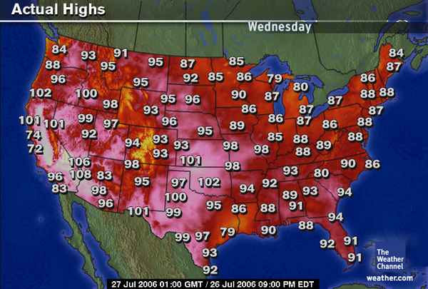
98 degrees in St. Louis yesterday? Horse feathers! Both temperature gauges, the one on my patio and the one in my Jeep, read 103 degrees when I checked around noon. The bad news is 55,000 homes were still without power here in St. Louis nine days after the storm that knocked power out on July 19. There have been nine heat-related deaths in the last week and a half here.
Ameren promises to have power back on to everyone today or tomorrow. Considering there were half a million without power (including yours truly) right after the storm, I figure they’ve done a fairly decent job of getting us all cooled down. Temps across the rest of the nation aren’t much better. Drink lots of water, stay indoors or in the shade if possible and don’t overly exert yourself during mid-day hours.
Just in case you’re feeling sorry for yourself, take note: today’s forecast for Baghdad is 119 degrees. It’s even hotter if you’re hoofing it, out on patrol in Injun Country. By the way ... the cartoon below the weather map is not funny ....
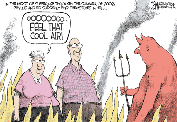
Cameron (Cam) Cardow - The Ottawa Citizen
Posted by The Skipper
Filed Under: • Climate-Weather •
• Comments (7)
Friday - July 21, 2006
Here We Go Again
Folks to the East of us better hang onto your hats.
Posted by The Skipper
Filed Under: • Climate-Weather •
• Comments (3)
Thursday - July 20, 2006
Darkness Falls
There I sat, watching Fox News chewing away on leftover pizza and suddenly the bass drums and cymbals started up and bright lights started flashing. The opera was about to begin. It was around 6:30pm last night and hadn’t even got real dark yet. It was about to.
BOOM! BOOM! CRASH! KA-BOOM! All around us. I hadn’t heard racket like this since I lived in New Orleans and we had to put up with the thunderboomers every single afternoon. The storm gods were having a field day. Then they decided to get serious. A few REALLY loud crashes and all of a sudden Shep Smith was cut off in mid-sentence. Silence. More crashing for about an hour then nothing. The electricity in the apartment went away to hide from its big brother playing around outside. Darkness descends.
The apartment started to get warm so I decided to throw in the towel and turn in. The UPS’s on my servers protected everything but they were only good for about 30 minutes. I powered the home network off and settled into bed in dead silence. Until the clock on the wall decided to tick louder than thunder. Remove battery from clock, go to sleep.
About 2:00 I woke up in miserable heat. An excursion to the basement, where it was cool, ended up uncovering my night’s resting place. Sometime around 5:15am, I was in the bathroom on the throne, reading the Weekly Standard by candlelight (you ought to try it some time) when power finally came back on. Relief, at last!
Now for the bad news, if you live in St. Louis get ready. The weatherman just said we stand a good chance of a repeat performance tonight. Ya know, I kinda miss the Gulf Coast and those annoying little hurricanes ...
Storms Cut Power, Snap Trees, Topple Trucks Across Region
(St LOUIS POST-DISPATCH) - 07/19/2006
A powerful summer storm slammed into the St. Louis area Wednesday evening, toppling buildings, street lights, tractor trailers and hundreds of trees. At least 476,000 customers lost power, Metrolink was shut down and just one-third of flights were getting in and out of Lambert Field.
“This is one of the worst storms we can all remember to hit the city of St. Louis in recent years,” St. Louis Mayor Francis Slay said at a hurriedly called news conference. The power outages will present a challenge to utility crews trying to get the power back on in temperatures expected to exceed 100 degrees today.
Until Wednesday, the two biggest storms to hit the area in the last few years were in July 2004, when about 225,000 lost power, and in August 2005, which affected about 250,000. It took AmerenUE crews four days to restore power to all customers in 2004 and five days in 2005.
The storm brewed quickly in central Illinois and swept southwest toward the St. Louis area shortly after 7 p.m. Meteorologists said the storm was unusual, not because of its path, but because a powerful “gust front” preceded the rain and thunder, causing damage from St. Charles County in the west to Madison County in the east, but hitting St. Louis and St. Louis County hardest.
Skies darkened with blowing dust, shingles flew from roofs, and windows were shattered, all before a drop of rain fell. Blowing dust and debris and then torrents of rain limited visibility on roads.
Westbound lanes of Highway 370 were shut down at the Discovery Bridge across the Missouri River because of at least two overturned tractor-trailers, according to the Missouri Highway Patrol. In downtown St. Louis, part of the Switzer building near the Eads Bridge collapsed onto the bridge, trapping a driver - eight months pregnant - in her car for some time.
By noon today, airline travel had returned to normal at Lambert Field. Passengers whose luggage was stranded at the airport’s Main Terminal because of the Wednesday night power outage returned to the baggage claim area to hunt for their bags.
Posted by The Skipper
Filed Under: • Climate-Weather •
• Comments (6)
Tuesday - July 18, 2006
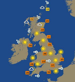
Heat Wave, British Version
One of the nice things about the metric system is that 37°C just doesn’t seem as hot as 100°F - unless you’re out in that heat. The current heat wave is affecting Britain almost as badly as the US. The only difference is we have nicer beaches and skimpier bikinis. If this keeps up, our Brit friends may even have to start drinking cold beer.
Of course you all realize that this is just more evidence of glowball warming and it’s all George Bush’s fault. It’s true. Al Gore said so ... and Al Gore is an expert on weather and climate. In much the same manner as Bill Clinton is an expert on gynecology.
(BBC) - Tuesday, 18 July 2006, 01:42 GMT 02:42 UK
The heatwave across England is set to continue, with temperatures expected to hit up to 34C (93F). Monday was the hottest day of the year so far with a reading of 32.7C (90.9F) at Heathrow airport, and the south east is again due for the highest figures.
Forecasters say Yorkshire and Humber is expected to experience the hottest July weather in nearly two decades. Monday’s heat caused rail lines to buckle in the Midlands, while glass panels fell at a Newcastle bus station.
Temperatures topped those in Spanish resorts, with 33C (91F) recorded in the south of England, higher than in Ibiza - 31C (88F) - and the Canary Islands - 27C (81F). The BBC Weather Centre said it expected London temperatures to reach 37C (99F) on Wednesday, breaking the July record of 36C (97F), seen in Epsom, Surrey, in 1911.
BBC weather forecaster Tomasz Schafernaker added there was a “10% chance” the UK’s all-time record of 38.5C (101F), recorded in August 2003, could even be beaten. “On Tuesday and Wednesday, temperatures in the Midlands will rise to around 34C and 35C so already there will be some local records broken for July,” he said.
He said temperatures would ease off to around 30C in the Midlands and South East on Thursday and Friday. Meanwhile, the Met Office recommended people stay hydrated in the heatwave conditions. Transport for London repeated its advice to passengers to carry water with them on the Underground.
Precautionary speed restrictions were in place on the District, Piccadilly, Metropolitan, Jubilee and Northern lines. North-east England had around a 70% chance of meeting its heatwave conditions, said the Met Office. The region must be 28C (82F) for two days, with a night temperature or 15C (59F).
Posted by The Skipper
Filed Under: • Climate-Weather •
• Comments (6)
Monday - July 17, 2006
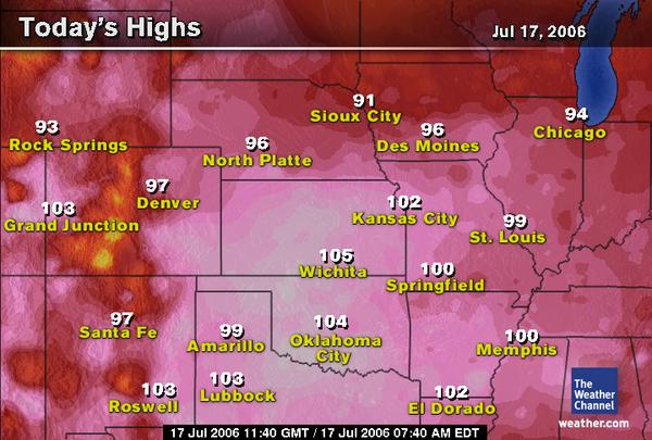
Hot Enough For Ya?
...EXCESSIVE HEAT WARNING REMAINS IN EFFECT UNTIL 7 PM CDT FRIDAY…
AFTERNOON HIGH TEMPERATURES ARE EXPECTED TO BE AROUND 100 DEGREES THROUGH FRIDAY IN THE ST. LOUIS METROPOLITAN AREA...WITH HEAT INDEX READINGS BETWEEN 105 AND 110 DEGREES. OVERNIGHT LOW TEMPERATURES IN THE UPPER 70S AND LOWER 80S WILL PROVIDE LITTLE RELIEF FROM THE DANGEROUSLY HOT DAYTIME CONDITIONS.
Posted by The Skipper
Filed Under: • Climate-Weather •
• Comments (4)
Friday - June 23, 2006
Climate Cycles
The longer this goes on, the sillier it gets. Al Gore needs to be locked up in a padded cell for pushing this mumbo-jumbo science. I know the real reason why temps are higher - there are too many people. That’s right. Since the Earth’s population exploded in recent centuries from a few million to several billions, that means there are way too many 98.6 degree warm bodies around. It’s true! Here’s my theory ...
The coldest winter in recent history was during WWII after millions of warm bodies went cold. The winter of 1944 was the coldest it had been in over a century. The second coldest winter was in 1914. Once again, after a major depopulation event. Duh! That proves my theory. The obvious solution to global warming is for the human race to have another great big, hairy war! Trust me, it’ll work!
—(AP via BREITBART)
Jun 22 4:51 PM US/Eastern
The Earth is running a slight fever from greenhouse gases, after enjoying relatively stable temperatures for 2,000 years. The National Academy of Sciences, after reconstructing global average surface temperatures for the past two millennia, said Thursday the data are “additional supporting evidence ... that human activities are responsible for much of the recent warming.”
Other new research showed that global warming produced about half of the extra hurricane-fueled warmth in the North Atlantic in 2005, and natural cycles were a minor factor, according to Kevin Trenberth and Dennis Shea of the National Center for Atmospheric Research, a research lab sponsored by the National Science Foundation and universities.
The academy had been asked to report to Congress on how researchers drew conclusions about the Earth’s climate going back thousands of years, before data was available from modern scientific instruments. The academy convened a panel of 12 climate experts, chaired by Gerald North, a geosciences professor at Texas A&M University, to look at the “proxy” evidence before then, such as tree rings, corals, marine and lake sediments, ice cores, boreholes and glaciers.
Combining that information gave the panel “a high level of confidence that the last few decades of the 20th century were warmer than any comparable period in the last 400 years,” the panel wrote. It said the “recent warmth is unprecedented for at least the last 400 years and potentially the last several millennia,” though it was relatively warm around the year 1000 followed by a “Little Ice Age” from about 1500 to 1850.

Tharg and me used to hunt mighty mammoth but he scared to cross ice bridge. It now too thin to take weight of even saber cat. Only mouse or rabbit can cross.
Many of my people have left the caves in search of food.
Sister’s daughter’s husband says it because of He-Who-Tamed-Fire. He say smoke from fire anger gods and they make it hot. Medicine Man say he full of mastodon droppings.
Medicine Man say Sun God told him Sun God get belly ache every 200 lifes of man. Belly ache make Sun God hotter, like when Og ate red berries birds don’t touch.
Sun God say it good thing. He say now we can go south past ice to land he call “Iowa.”
He mumble “junk science” and “media hype” and “poorly educated reporters.” We no understand these powerful magic words. We afraid to say words now that Moon God warn us. She say magic words make research grants dry up. We no understand.
Must go, little Ky-Rock need help flaking obsidian.

Posted by The Skipper
Filed Under: • Climate-Weather • Satire •
• Comments (9)
Sunday - June 11, 2006
Inna-Gadda-Da-Vida
You’ll have to pardon The Skipper this morning if I’m a little slow getting off the mark. Besides the fact that it’s Sunday morning, I was treated to an Iron Butterfly concert all last night - specifically the song mentioned in the title. Unfortunately, the concert was performed by Mother Nature and lasted the entire night.
The melody kicked off about 9:30pm and the drum solo lasted from 10:30pm last night until 5:00am this morning. The drums pounded constantly with strobe lights from the stage going off every five minutes. Boom, boom, flash, power-out!. Repeat until done. The windows rattled and the rain poured down. No rest for the weary last night.
The entire city of St. Louis will be sleeping in today, I expect. Just another of those nasty Midwest thunderboomers. All total, I think we got about 200 inches of rain last night. The hill behind my apartment decided to wander down into the parking lot - which is covered in about a foot of mud right now. We were under flash flood watches all night but now they are lifted and all is quiet outside. Maybe I can catch a little nap-time while we’re in the doughnut hole of this storm. It ain’t over yet.
In the meantime, we would like to present this little travel agency advertisement (Flash movie) to help you plan your next vacation. Experience Mexico! Follow the Smith family as they swim the river and take advantage of Vicente Fox’s hospitality. Just click the image below and enjoy the fun ...

(-- hat tip to Sdkar for the tip on this little movie gem--)
Posted by The Skipper
Filed Under: • Climate-Weather • Humor •
• Comments (4)
Saturday - June 10, 2006
Public Service Announcement
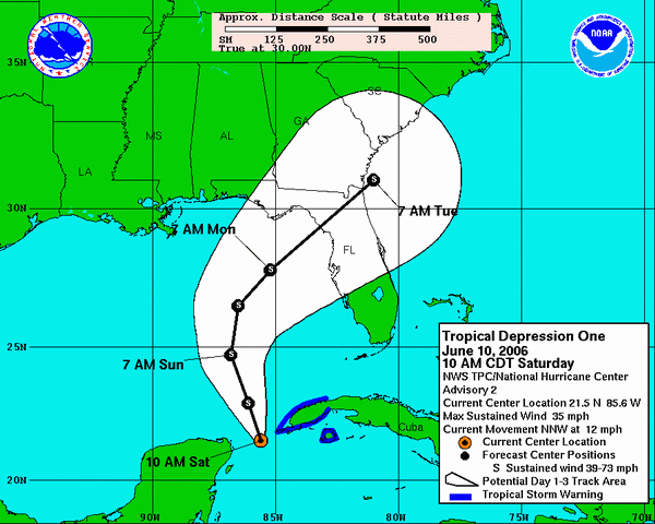
BULLETIN
TROPICAL DEPRESSION ONE ADVISORY NUMBER 2
NWS TPC/NATIONAL HURRICANE CENTER MIAMI FL AL012006
1000 AM CDT SAT JUN 10 2006
TROPICAL STORM WARNINGS ARE RECOMMENDED FOR THE CUBAN PROVINCES OF PINAR DEL RIO AND THE ISLE OF YOUTH.
INTERESTS ELSEWHERE IN THE EASTERN GULF OF MEXICO SHOULD MONITOR THE PROGRESS OF THIS SYSTEM.
FOR STORM INFORMATION SPECIFIC TO YOUR AREA...INCLUDING POSSIBLE INLAND WATCHES AND WARNINGS ... PLEASE MONITOR PRODUCTS ISSUED BY YOUR LOCAL WEATHER OFFICE.
AT 1000 AM CDT ... 1500Z ... THE POORLY-DEFINED CENTER OF TROPICAL DEPRESSION ONE WAS ESTIMATED NEAR LATITUDE 21.5 NORTH ... LONGITUDE 85.6 WEST OR ABOUT 45 MILES ... 75 KM...WEST-SOUTHWEST OF CABO SAN ANTONIO ON THE WESTERN TIP OF CUBA.
THE DEPRESSION IS MOVING TOWARD THE NORTH-NORTHWEST NEAR 12 MPH ... 19 KM/HR...AND THIS GENERAL MOTION IS EXPECTED TO CONTINUE FOR THE NEXT 24 HOURS. THIS MOTION SHOULD BRING THE CENTER OF THE DEPRESSION INTO THE SOUTHEASTERN GULF OF MEXICO LATER TODAY.
MAXIMUM SUSTAINED WINDS ARE NEAR 35 MPH ... 55 KM/HR...WITH HIGHER GUSTS. SOME STRENGTHENING IS FORECAST DURING THE NEXT 24 HOURS ... AND THE DEPRESSION COULD BECOME A TROPICAL STORM LATER TODAY. AN AIR FORCE RESERVE HURRICANE HUNTER AIRCRAFT IS SCHEDULED TO INVESTIGATE THE DEPRESSION THIS AFTERNOON. ESTIMATED MINIMUM CENTRAL PRESSURE IS 1003 MB ... 29.62 INCHES.
AT THIS TIME ... THE MAIN THREAT FROM THE DEPRESSION IS HEAVY RAINFALL. THE DEPRESSION IS EXPECTED TO PRODUCE TOTAL RAINFALL ACCUMULATIONS OF 10 TO 20 INCHES OVER THE WESTERN HALF OF CUBA ... WITH ISOLATED TOTALS OF 30 INCHES OVER THE HIGHER TERRAIN. THIS COULD CAUSE DEVASTATING FLASH FLOODS AND MUD SLIDES. GRAND CAYMAN ISLAND HAS REPORTED 22.72 INCHES OF RAIN DURING THE PAST 24 HOURS ... AND ADDITIONAL RAINFALL OF 5 TO 10 INCHES IS POSSIBLE OVER THE CAYMAN ISLANDS. RAINFALL TOTALS OF 3 TO 5 INCHES ARE POSSIBLE OVER THE NORTHEASTERN PORTION OF THE YUCATAN PENINSULA. THERE IS ALSO THE POTENTIAL FOR HEAVY RAINFALL OF 4 TO 8 INCHES POSSIBLE OVER THE FLORIDA KEYS AND WESTERN FLORIDA FROM SUNDAY INTO MONDAY.
Posted by The Skipper
Filed Under: • Climate-Weather • Satire •
• Comments (7)
Wednesday - April 26, 2006
Hot Air
Riddle me this: You live in New Orleans and your house was flooded and half the town destroyed last September by a monster hurricane. Who or what is responsible for your loss? (A) the Corps Of Engineers (see post below this one) for building a ship canal, (B) people driving too many gas-guzzling SUV’s, spewing out carbon monoxide, (C) your own dumb ass for building a house on the coast in a city that is twelve feet below sea level? Try not to get stuck on stupid when you answer that.
Experts: Global Warming Behind 2005 Hurricanes
Wednesday, April 26, 2006 - 7:17 a.m. EDT (11:17 GMT)
MONTEREY, California (Reuters)—The record Atlantic hurricane season last year can be attributed to global warming, several top experts, including a leading U.S. government storm researcher, said on Monday.
“The hurricanes we are seeing are indeed a direct result of climate change and it’s no longer something we’ll see in the future, it’s happening now,” said Greg Holland, a division director at the National Center for Atmospheric Research in Boulder, Colorado.
Holland told a packed hall at the American Meteorological Society’s 27th Conference on Hurricanes and Tropical Meteorology that the wind and warmer water conditions that fuel storms that form in the Caribbean are “increasingly due to greenhouse gases. There seems to be no other conclusion you can logically draw.”
His conclusion will be debated throughout the week-long conference, as other researchers present opposing papers that say changing wind and temperature conditions in the tropics are due to natural events, not the accumulation of carbon dioxide emissions clouding the Earth.
Many of the experts gathered in the coastal city of Monterey, California, are federal employees. The Bush administration contends global warming is an unproven theory.
While many of the conference’s 500 scientists seem to agree that a warming trend in the tropics is causing more and stronger hurricanes than usual, not all agree that global warming is to blame.
Some, like William Gray, a veteran hurricane researcher at Colorado State University in Fort Collins, Colorado, attributed the warming to natural cycles.
Gray said he believes salinity buildups and movements with ocean currents cause warming and cooling cycles. He predicted the Caribbean water will continue to warm for another five to 10 years, then start cooling.
Posted by Ronald Reagan's Ghost
Filed Under: • Climate-Weather •
• Comments (5)
Monday - April 03, 2006
Killer Storm
It was all over in about thirty minutes. I left the apartment around 4:30pm yesterday to go pick up lease papers at the complex office and grab some takeout at KFC for supper. All day long we had bright sunny skies and temps in the mid-70’s. When I left the complex office, I noticed the sky had turned black as night with an ugly, boiling purple mass spreading outward over my head. I started humming the theme music from “Ghostbusters”.
As I headed to the local KFC about a mile away, it started to rain. Just about the time I pulled up to the order window all hell broke loose. Wind started rocking my 3-ton Grand Cherokee, debris came flying overhead from someone’s roof and marble-sized hail started pounding down on me. The Jeep shook and bounced as more signs and tree limbs went flying overhead. Like an idiot, I just sat there and kept screaming at the little speaker to order my chicken. By the time I pulled out of the parking lot with my supper, the scene from “Ghostbusters” was over and Gozar The Destroyer had moved on into Illinois. Are we having fun yet ... ?
Two Killed As Storm Batters St. Louis
April 2, 2006
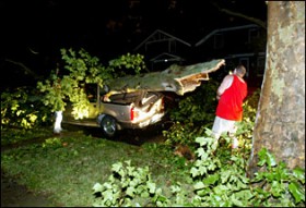
A fast-moving storm packing powerful winds tore through the St. Louis area Sunday afternoon, killed at least two people, damaged buildings and cut electricity for up to 270,000 customers across Missouri and Illinois. One man was killed by a falling tree while walking on a trail in Castlewood State Park near Ballwin, said Tracy Panus, a spokeswoman for St. Louis County police. She would not identify the victim Sunday night.
Another person was killed when part of the roof of a K&G Clothing Store in Fairview Heights collapsed. Elsewhere in Missouri, the violent weather “destroyed just about everything” in Caruthersville, the Pemiscot County seat, dispatcher Dorothy Hale said. Dark thunderclouds rolled in from the west shortly after 5 p.m., uprooting trees and snapping power lines in St. Louis County and the Metro East, where some of the worst damage was reported.
Emergency officials say the same storm system also killed 14 people in west Tennessee, the Associated Press reported. The storm’s fury spared few parts of the bistate area. It carried winds gusting up to 70 mph in St. Charles County and formed what may have been tornadoes in Randolph County, Ill., according to the National Weather Service. Tornadoes may have touched down near Junction City, Ill., and in Randolph County in Illinois, meteorologists said. The weather service said softball-size hail also was reported in some areas.
Forecasters called for breezy weather today, including wind gusts up to 35 mph and temperatures in the mid-50s. But more showers and thunderstorms - perhaps severe - return to the forecast for Wednesday night. Sunday’s storm dropped little rain - only a half-inch at Lambert Field - but brought powerful winds that knocked down trees and damaged houses and businesses. Power was out to as many 158,000 homes in the St. Louis area. Crews were working to restore electricity late Sunday night, and additional crews were called from Kansas City to help with the work.
Posted by The Skipper
Filed Under: • Climate-Weather •
• Comments (16)
Thursday - March 23, 2006
We’re Not in Missouri anymore Toto
Remember those twisters the Skipper was talking about the other day? This young man got the ride of his life! Too bad he doesn’t remember it.
Missouri teen survives ride in tornado
FORDLAND, Mo. — Matt Suter can’t get the tornado out of his head — or his ears.
Every time a late-night freight train thunders past, Suter wakes up and remembers the vicious twister that pulled him from his home March 12 and landed him in a pasture — a quarter-mile away.
Suter’s harrowing encounter has brought him sudden fame, with national media exposure. One tornado expert said he knew of no one who traveled as far as Suter did in a tornado and lived to tell about it.
“It’s a pretty awkward record to have,” the 19-year-old senior at Fordland High School said.
The soft-spoken Suter did not court attention about his experience, which was not reported publicly until a week after it happened.
On the night of the tornado, Suter said, he was watching television news in only his boxer shorts when he heard a jetlike roar approaching the trailer he shared with his grandmother and uncle.
He was trying to shut a window in the living room, and his grandmother was in the kitchen, when the tornado struck, he said.
“The window busted, and the door got sucked out,” Suter said. “I looked at my grandmother, and the walls were like Jell-O. The trailer was rocking back and forth. I jumped between the coffee table and couch, and I remember the trailer tipping.”
His grandmother, Linda Kelley, said Suter had hollered at her in the trailer, and when she came into the kitchen “I turned around to look at where he was, and that whole end of the trailer was just gone.”
A large heavy glass lamp struck Suter on the top of his head, knocking him unconscious, he said.
When he came to, Suter found himself in a soft, grassy pasture. Last week a global positioning satellite device used by National Weather Service meteorologist Dave Gaede measured the distance at 1,307 feet from the trailer site.
Posted by Drew458
Filed Under: • Climate-Weather •
• Comments (14)
Tuesday - March 21, 2006
Spring Has Been Postponed
Here we go again with more of that glowball warming crap. I got up a little after midnight to get a glass of water and just happened to glance out the kitchen window at the parking lot behind my apartment. My Jeep is covered in white crap and the entire ground around my apartment is about three inches deep in the stuff ... and it’s still coming down in big flakes. Temperature outside now is 21 degrees fahrenheit. This glowball warming better stop soon or I’m gonna freeze to death ....
SIOUX FALLS, S.D. (AP) - A powerful storm dumped more than a foot of snow in the Plains, closing schools and roads and forcing residents to man shovels Monday during the first day of spring. Hundreds of schools were closed in Nebraska, Kansas, Colorado and South Dakota, and at least five deaths were blamed on the storm. Spring officially began at 1:26 p.m. EST.
Myron Williams, who raises livestock near Wall, was busy shoveling a foot of snow from gates and feedlots on his property. The rancher said the work was hard but the precipitation was welcome. The National Weather Service was still compiling snowfall totals Monday, but parts of South Dakota and Nebraska got up to 18 inches. Northeast Colorado had at least a foot, northwest Kansas had up to 10 inches, and parts of the Oklahoma Panhandle got half a foot.
“We could be looking at over 20 inches by the time this is done,” said Kyle Carstens, a meteorologist with the weather service’s Rapid City office. Several stretches of Interstate 80 were closed in Nebraska, the State Patrol said. Parts of Interstate 70 were closed in western Kansas, and in Colorado more than 150 miles of the highway were shut down.
Posted by The Skipper
Filed Under: • Climate-Weather •
• Comments (24)
Friday - March 17, 2006
Stormy Weather
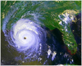
Attention Shoppers! You only have 76 days left until the all-new 2006 Hurricane Season begins. Stock up now on key items like bottled water, spare batteries, flood insurance and toilet paper. If you live in New Orleans, you may assume the requisite position by bending over, grasping your ankles firmly and repeating to yourself over and over again B-O-H-I-C-A ....
While the question of what role, if any, humans have had in all this is still a matter of intense debate, most scientists agree that stronger storms are likely to be the norm in future hurricane seasons.
The study is detailed in the March 17 issue of the journal Science. In the 1970s, the average number of intense Category 4 and 5 hurricanes occurring globally was about 10 per year. Since 1990, that number has nearly doubled, averaging about 18 a year.
Some scientists have explained the rising strength of hurricanes as being part of natural weather cycles in the world’s oceans. In the North Atlantic, this cycle is called the Atlantic multi-decadal mode. Every 20 to 40 years, Atlantic Ocean and atmospheric conditions conspire to produce just the right conditions to cause increased storm and hurricane activity.
The Atlantic Ocean is currently going through an active period of hurricane activity that began in 1995 and which has continued to the present. The previous active cycle lasted from the late 1920’s to 1970, and peaked around 1950.
“These cycles definitely do influence hurricane intensity, but they can’t be the whole story”, Judith Curry of the Georgia Institute of Technology said. While scientists expect stronger hurricanes based on natural cycles alone, the researchers suspect other contributing factors, since current hurricanes are even stronger than natural cycles predict.
“We’re not even at the peak of current cycle, we’re only halfway up and already we’re seeing activity in the North Atlantic that’s 50 percent worse than what we saw during the last peak in 1950,” Curry said.
Posted by The Skipper
Filed Under: • Climate-Weather •
• Comments (11)
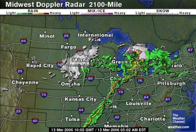
Monday - March 13, 2006
Ground Zero
Have you ever wondered what it feels like to hunker down in a foxhole while artillery falls all around you, blowing huge holes in the earth as you pull your helmet tight on your head, curl up and wait it out? If not, you ought to come live in the Midwest during Spring. That’s what the last 48 hours have been like here in St. Louis. Tornados have been touching down all around us as a massive thunderstorm front rolled through over the weekend.
At last count the death toll was at seven nine ten. I’ve been sitting here with boiling black skies all around me with lightning flashes to occasionally illuminate clouds where ”they” hide. “They” are those nasty little funnels that drop down out of a cloud, savagely attack any mobile homes in sight then jump back up into the clouds. They don’t play fair. There’s almost no way to tell where the next one will appear. It’s almost like playing Russian Roulette. You never know.
As for me, I’m got some essentials in the basement (bottled water, canned food, spare clothes ... “personal protection") just in case. Power has been off and on a few times but everything seems to have danced all around us here in St. Louis. Folks to the North, West and South of us haven’t been as lucky. They’re still trying to go through the debris. That’s the good news. The bad news is everything East of us is in the gun sights. You kids in Illinois, Indiana, Ohio and Kentucky better get ready. I hope your foxhole is as lucky as mine was ....
‘The Trailer Came Down Right On Top Of Her’
Storms leave 5 people dead in Midwest
Monday, March 13, 2006 3:46 a.m. EST (08:46 GMT)
(CNN)—Tornadoes rampaged through the heart of Missouri and into Illinois on Sunday, killing at least five people, authorities said, capping a weekend that had already seen two deaths blamed on severe weather. “One hundred homes or businesses received significant damage or were destroyed,” said Pettis County, Missouri, presiding commissioner Rusty Kahrs. He said at least three tornadoes had touched down in Pettis County, about 70 miles east-southeast of Kansas City.
Kahrs identified the fatality as 39-year-old DeAnn Frances Follman, who he said was exiting her mobile home when the storm hit. He said six others were injured and two were missing. A neighbor of Follman’s told The Associated Press: “The trailer came down right on top of her.” According to Kahrs, one of the tornadoes cut a half-mile-wide, 20-mile-long swath through the county late Sunday afternoon.
As the deadly line of thunderstorms rumbled to the northeast, Randolph County was next. According to Randolph County Coroner Gerald Luntsford, four people died in Moberly after their homes were destroyed by winds. The deaths occurred in three different homes. The damage stretched into northeastern Missouri.
“We’ve got buildings and mobile homes flattened—people are injured or trapped,” a harried Monroe City police dispatcher said. “It’s hard to give you anything firm because reports keep coming in.” The National Weather Service Web site said there were reports of people trapped in a damaged church.
The NWS also reported a confirmed a tornado near the Cedar County seat of Stockton, about 120 miles south of Kansas City, about 9:40 p.m. (10:40 p.m. ET). “We have damage and some injuries. We don’t know how many,” said Doug Miller, a dispatcher for the Cedar County Sheriff’s Department.
Posted by The Skipper
Filed Under: • Climate-Weather •
• Comments (30)
Five Most Recent Trackbacks:
Once Again, The One And Only Post
(4 total trackbacks)
Tracked at iHaan.org
Th’Įģ advantage to having a guide with you is th╔æt an expert will hačĄe very first hand experience dealing and navigating the river with ą│egional wildlife. Tę╗omas, there are great…
On: 07/28/23 10:37
The Brownshirts: Partie Deux; These aare the Muscle We've Been Waiting For
(3 total trackbacks)
Tracked at head to the Momarms site
The Brownshirts: Partie Deux; These aare the Muscle We’ve Been Waiting For
On: 03/14/23 11:20
Vietnam Homecoming
(1 total trackbacks)
Tracked at Õ╣┐ÕæŖõĖōķóśķģŹķ¤│ õĖōõĖÜõ╗Äõ║ŗõĖŁµ¢ćķģŹķ¤│ĶĘ¤Õż¢µ¢ćķģŹķ¤│ÕłČķĆĀ’╝īÕīŚõ║¼ÕÉŹõ╝ĀÕż®õĖŗķģŹķ¤│Õģ¼ÕÅĖ
ŃĆĆŃĆĆõĖōõĖÜõ╗Äõ║ŗõĖŁµ¢ćķģŹķ¤│ÕÆīÕż¢µ¢ćķģŹķ¤│ÕłČõĮ£’╝īÕīŚõ║¼ÕÉŹõ╝ĀÕż®õĖŗķģŹķ¤│Õģ¼ÕÅĖ ŃĆĆŃĆĆÕīŚõ║¼ÕÉŹõ╝ĀÕż®õĖŗõĖōõĖÜķģŹķ¤│Õģ¼ÕÅĖµłÉńĀ┤õ║Ä2006Õ╣┤12µ£ł’╝īµś»õĖōõĖÜõ╗Äõ║ŗõĖŁ õĖŁµ¢ćķģŹķ¤│ µ¢ćķģŹķ¤│ĶĘ¤Õż¢µ¢ćķģŹķ¤│ńÜäķ¤│ķóæÕłČķĆĀÕģ¼ÕÅĖ’╝īÕ╣╗µā│ķŻ×ĶģŠķģŹķ¤│ńĮæķóå ķģŹķ¤│ÕłČõĮ£ µ£ēµĄĘÕåģÕż¢õ╝śĶē»õĖōõĖÜķģŹķ¤│ĶüīÕæśÕĘ▓ĶŠŠ500ÕżÜõĮŹ’╝īÕÅ»õŠøń╗ÖõĖƵĄüńÜäÕż¢Ķ»ŁķģŹķ¤│’╝īķĢ┐Õ╣┤µ£ŹÕŖĪõ║ÄÕøĮÕåģõĖŁÕ┐āń║¦ÕÉäÕż¦Õ¬ÆõĮōŃĆüÕÉäń£üÕĖéńöĄÕÅ░ńöĄĶ¦åÕÅ░’╝īĶāĮµ╗ĪµäÅõĖŹÕÉīÕ«óµłĘńÜäÕÉäń¦Źķ£ĆĶ”üŃĆéńöĄĶ»Ø’╝Ü010-83265555 ŃĆĆŃĆĆÕīŚõ║¼ÕÉŹõ╝ĀÕż®õĖŗõĖōõĖÜķģŹķ¤│Õģ¼ÕÅĖ…
On: 03/20/21 07:00
meaningless marching orders for a thousand travellers ... strife ahead ..
(1 total trackbacks)
Tracked at Casual Blog
[...] RTS. IF ANYTHING ON THIS WEBSITE IS CONSTRUED AS BEING CONTRARY TO THE LAWS APPL [...]
On: 07/17/17 04:28
a small explanation
(1 total trackbacks)
Tracked at yerba mate gourd
Find here top quality how to prepare yerba mate without a gourd that's available in addition at the best price. Get it now!
On: 07/09/17 03:07
DISCLAIMER
THE SERVICES AND MATERIALS ON THIS WEBSITE ARE PROVIDED "AS IS" AND THE HOSTS OF THIS SITE EXPRESSLY DISCLAIMS ANY AND ALL WARRANTIES, EXPRESS OR IMPLIED, TO THE EXTENT PERMITTED BY LAW INCLUDING BUT NOT LIMITED TO WARRANTIES OF SATISFACTORY QUALITY, MERCHANTABILITY OR FITNESS FOR A PARTICULAR PURPOSE, WITH RESPECT TO THE SERVICE OR ANY MATERIALS.
Not that very many people ever read this far down, but this blog was the creation of Allan Kelly and his friend Vilmar. Vilmar moved on to his own blog some time ago, and Allan ran this place alone until his sudden and unexpected death partway through 2006. We all miss him. A lot. Even though he is gone this site will always still be more than a little bit his. We who are left to carry on the BMEWS tradition owe him a great debt of gratitude, and we hope to be able to pay that back by following his last advice to us all:
It's been a long strange trip without you Skipper, but thanks for pointing us in the right direction and giving us a swift kick in the behind to get us going. Keep lookin' down on us, will ya? Thanks.
- Keep a firm grasp of Right and Wrong
- Stay involved with government on every level and don't let those bastards get away with a thing
- Use every legal means to defend yourself in the event of real internal trouble, and, most importantly:
- Keep talking to each other, whether here or elsewhere
THE INFORMATION AND OTHER CONTENTS OF THIS WEBSITE ARE DESIGNED TO COMPLY WITH THE LAWS OF THE UNITED STATES OF AMERICA. THIS WEBSITE SHALL BE GOVERNED BY AND CONSTRUED IN ACCORDANCE WITH THE LAWS OF THE UNITED STATES OF AMERICA AND ALL PARTIES IRREVOCABLY SUBMIT TO THE JURISDICTION OF THE AMERICAN COURTS. IF ANYTHING ON THIS WEBSITE IS CONSTRUED AS BEING CONTRARY TO THE LAWS APPLICABLE IN ANY OTHER COUNTRY, THEN THIS WEBSITE IS NOT INTENDED TO BE ACCESSED BY PERSONS FROM THAT COUNTRY AND ANY PERSONS WHO ARE SUBJECT TO SUCH LAWS SHALL NOT BE ENTITLED TO USE OUR SERVICES UNLESS THEY CAN SATISFY US THAT SUCH USE WOULD BE LAWFUL.

Copyright ┬® 2004-2015 Domain Owner
Oh, and here's some kind of visitor flag counter thingy. Hey, all the cool blogs have one, so I should too. The Visitors Online thingy up at the top doesn't count anything, but it looks neat. It had better, since I paid actual money for it.